|
THE SCIENCE OF SLIDES:
A Primer on How Debris Flows Work
BY JEN
SHAFFER
Rumble. Rumble. The roaring grows. Suddenly a wall
of boulders, trees, rocks, and mud appears around a bend in a narrow
canyon. It rushes downhill, picking up speed, clanking and grinding and
destroying everything in its path.
The mass of stuff finds the stream channel at the
bottom of the canyon and continues its destructive journey to the bottom
of the mountain. In its wake, the earth is stripped bare to the bedrock.
Wiped clean -- left to begin a new cycle of soil rebuilding and
revegetation.
But what happened?
Recent deaths in Oregon's forest interface have
focused attention on landslides and their causes. Many individuals point
to clearcuts as the cause of the increased slide activity, but other
factors help create slides. Steep slopes, over-saturated soils, vegetation
cover, and previous land use work together to produce debris flows that
smother salmon spawning grounds, move boulders and trees, and kill people.
Currently, scientists have enough information to understand how slides
work and what areas are more likely to have slides. The following is a
layperson's guide to the science of landslides.
Landslides & Mudslides
Debris flow is a generic term used by scientists to
describe the rapid movement of rocks, soil, water, and vegetation
downhill. A debris flow could be a mudslide or a landslide, depending on
the amount of water present. Flows contain many different-sized particles
from sand grains to boulders, but the biggest rocks travel at the front of
the flow.
Debris flows are a natural occurrence. In fact,
Gordon Reed, a fish biologist with the U.S. Forest Service Research Lab in
Oregon, says that flow events are a major force in delivering wood and
gravel to streams to create fish habitat.
Landslides are at the drier end of the debris flow
spectrum. Their smaller water content makes them more like oatmeal on a
camping trip -- sticky, gloopy, and full of sticks and rocks. Landslides
are classified by the speed at which they move. "Creeps" move only a few
inches downhill a year, but given enough time they can push railroad
tracks and fences out of line. Avalanches move very fast, sometimes at
speeds greater than 60 mph. These rapid landslides occur in mountainous
areas and may be made of snow or rock.
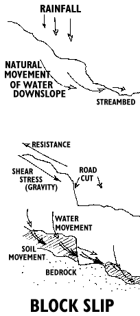
Landslides come in two forms: block slips and
rotational block slips.
Block slips happen when a hillside is cut
into, such as when a road is made. Shear stress, the force that wants to
tear the soil from the bedrock, is usually balanced by resistance to
downhill movement. Shear stress forms along the slip plane, the interface
between soil and solid bedrock. Resistance is provided by roots holding
soil to the slope, or soil particles clinging to one another and the
bedrock. Normally, rain percolates through the soil -- or a porous layer
of rock -- to the water table, and flows downhill from there. If the
bedrock is not absorptive, the water runs downhill through the soil along
the slip plane.
Road-building upsets this balance, and heavy rain
can break down resistance to a point where shear stress takes over and the
hill comes tumbling down.
When a road is cut into a slope, the water flowing
downhill seeps out of the side of the cut and across the road surface,
then continues on its path to the bottom of the hill. If lots of rain
falls in a very short period of time, the soil above the road gets
supersaturated with water and becomes a big muddy mass. If the mass is not
held to the slope by vegetation, it may start to move downhill, picking up
loose rocks and vegetation. Eventually, the flow reaches the road cut and
dumps everything onto the surface. If the debris flow has enough speed and
force, it can move across the road and continue its path downhill.
Rotational block slip is a term scientists
use to describe slumps. A slump is the slippage of a whole block of earth
at once. The soil moves in one piece, leaving a smooth rock face.
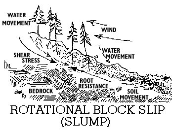
Several forces work together to create slumps.
Usually resistance to downhill movement is created by roots holding soil
together and/or soil particles sticking together. Wind pushing against the
vegetation can loosen roots -- and therefore soil. Heavy rain, combined
with shear stress and wind, works to pull the soil downward. Again, the
saturated soil can get loosened enough to move downhill, taking the
vegetation and loose rock with it. A slump can trigger further debris
flows at its leading edge.
Mudslides contain more water than landslides. They
can contain solid material, too, but generally have fewer large rocks and
trees than landslides. Mudslide consistency is a lot like cake batter --
with a few sticks and pebbles thrown in.
Mudslides can move as fast as 22 mph because of
their high water content. Heavy rains and rapid snowmelt can trigger mud
flows on unstable slopes. Mudslides formed after Mount St. Helens erupted,
because the heat and lava quickly melted the snow blanketing the mountain.
The Role of Water
Water plays a big role in triggering landslides; it
acts like WD-40 on a rusty screw. Water lubricates the surface between the
soil (or sometimes weathered rock) and the bedrock, and makes it easier
for the soil to slide off the solid underlying hillside. If the soil is
already saturated, a period of heavy rain can trigger a slide.
Keith Mills, a geological specialist at the Oregon
Department of Forestry, says that two to five inches of rainfall in six
hours, after a few days of prior rain, is enough to trigger a debris flow.
Hubbard Creek had seven inches in 10 hours last
November prior to the fatal landslide.
Water combined with gravity is a powerful force in
moving earth. How heavy is water?
"When it rains two inches in 24 hours, you have
about 10 pounds of water on every square foot of soil," explains Tom
Horning, a geological hazards specialist at Horning Geosciences in
Seaside, Oregon. "That's about 50,000 pounds of water on a 50-by-100-foot
lot. After four or five days, you could have 125 tons of water, and that
water's got to go somewhere."
Last year's heavy rainfall is not likely to let up
in the near future. Climatologists believe we've entered the wet end of a
20-year wet/dry climate cycle. Although we can expect a few dry years,
precipitation even then is expected to be higher than in the last 20-year
dry cycle between 1974 and 1994.
Soil & Bedrock
Soil composition and bedrock also determine where
debris flows occur. The looser the soil, the more likely it will move if
nothing is there to hold it down.
Soils with greater clay content stick together
better because the clay particles absorb water slowly and stick together.
Soils with more organic material -- such as forest soils -- act like
sponges to soak up excess water. When the spongy layer is removed by
logging or burning, or compacted by heavy machinery, excess water flows
over the surface and erodes the top layer of soil. When the underlying
bedrock is porous, such as sandstone or some volcanic-formed rock, soils
drain faster. Impermeable bedrock, such as granite, keeps water in the
soil. Over time, the excess water is transferred down to the water table
or to stream channels, and some is stored for future use by plants.
Jointed bedrock is subject to increased landslide
risk depending on which way the cracks form. Joints form between
horizontal layers of rocks and at cracks created during normal earth
movement. Water seeps through porous bedrock (such as sandstone) to
existing cracks or layers in the rock. Horizontal joints, parallel to the
topsoil, provide little resistance to sliding. The water lubricates the
layers, creating a slip plane, and causes them to slide against one
another like two pieces of paper. Vertical cracks in bedrock, however, can
actually help stabilize the slope by absorbing and diverting water. If
roots can get down into the cracks, the soil is further stabilized.
Bedrock type can also determine slide potential.
Some rock, such as shales and volcanic-formed rocks, weather into sticky
clay soils. Sandstones, granites, and micas wear down into coarse porous
soils that are easily moved.
Slope
The steeper the slope, the more likely it is to
slide. Landslides can occur on very gentle slopes, but these usually take
years. The soil creeps slowly downhill, moving fenceposts and realigning
railroad tracks. Wash gullies, which funnel eroded soil downhill, form
more often on slopes greater than 40 percent (22 degrees). Quicker debris
flows take place on slopes greater than 50 percent (27 degrees). The
landslides last November along the lower Umpqua River occurred on slopes
of 60 percent (31 degrees) or steeper.
How do these percentages translate into angle
degrees? A rough estimate of a 100 percent slope would be about 45
degrees. A 200 percent slope is about 90 degrees.
Vegetation
The effect that vegetation cover has on hillslopes
and slide potential is complicated. Trees intercept rain, lessening the
impact that individual raindrops have on soil, and shade from trees keeps
the forest floor moist and cool.
If you've ever stood out in an Oregon rainstorm, you
know how hard those drops can hit. Just imagine what those raindrops do to
dried-out exposed soil. Rain hitting the ground loosens soil and small
pieces of rock. Plants absorb the force of the rain and take up water for
their own growth.
Roots hold soil down. Trees have larger and deeper
root systems than grasses or shrubs, and are therefore more effective in
retaining soil. When trees are cut, though, their roots die and quickly
begin to decay. As the roots rot, they lose their ability to hold soil.
The roots eventually decay to the point where they become part of the
soil.
Meanwhile, grasses, shrubs, and new trees begin to
grow on the site where trees were cut. As the new trees grow, their roots
gain strength in retaining soil. For a few years, the grasses and shrubs
are the most important factor in holding down soil.
Donald Satterlund and Paul Adams, forest
researchers at Washington and Oregon State Universities, report that root
cohesion -- the ability of roots to hold the soil to the slope -- reaches
its lowest point 10 years after a clearcut. At the 10-year point, new
growth is still not able to take up the slack left by decaying roots. The
rotting roots have reached the point where only the largest main pieces of
the roots remain.
However, strong winds blowing on treetops can
weaken the hold of the roots on the soil. The tree trunk acts like a
crowbar: Wind pushes down on the treetop "handle" and pries up the soil
with the roots. The resultant loss in slope stability can create a slump.
Bare soil erodes rapidly. Removal of vegetation
has been shown to increase runoff. If water is moving on top of the soil,
it has a greater ability to move loose soil, rocks, and plant material.
Previous Use
Previous land use is probably one of the most
easily determined factors in predicting a landslide. Piling heavy material
such as mine tailings and dirt from roadcuts on hillslopes can cause
failure.
Slopes cleared for houses in the forest interface
can create problems, too. Such an area is cleared of trees and grass, and
then leveled to create flat building site. Some trees and shrubs may be
planted after the house is finished, but these cannot replace the root
cohesion of the removed vegetation. The landslides on Puget Sound in
January 1997 occurred on cliffs adjacent to a housing development. Placing
leach field septic systems on developed hillsides saturates soils with
water so that when heavy rainfalls happen, the slope is set up for a
slide.
Researchers at the H.J. Andrews Experimental
Forest have found roads to be the most important factor contributing to
slope failure. Roads act like stream channels. Water normally moves
downhill through soil to a stream channel. At the stream, the water
resurfaces and joins a network of streams and rivers flowing to the sea.
During the dry season, water may move through the
soil down to the water table where it is kept in reserve. When a road is
cut into a hillside, it intercepts the water flowing downhill through the
soil to the stream channel. Some water may flow under the road, but most
of it moves across the roadtop. Depending on how close the stream is to
the road, i.e. how close the road is to the bottom of the slope,
the resurfaced water may have to travel a distance. The impact of water
falling over the edge of the road can erode the soil on the slope between
the road and the stream. A large amount of water moving over the road edge
could trigger a slide. The old cut-and-fill method of road building piled
rock and soil removed from the roadcut on the downhill slope. This made
slopes even steeper and more prone to movement. Culverts, used to divert
water and streams under roads, channel water into quicker moving streams
that can erode soil faster. Scientists at H.J. Andrews have found that
gullies are more likely to form on slopes greater than 40 percent below
road culverts.
As previously mentioned, trees contribute to slope
stability by holding the soil down with their roots and intercepting rain
-- but they also decrease snowmelt and rain runoff, which can quickly
erode bare earth. When trees are harvested, particularly in a clearcut,
runoff increases, rain hits the soil more forcefully, and root cohesion
decreases. In some harvest areas, headwalls -- the part of the slope most
likely to fail -- are left uncut to try to decrease the chance of a
landslide. But steep slopes eventually fail with or without human
interference.
Clearcuts in combination with roads have the
greatest chance of creating debris flows during heavy rains. In an
experiment at the H.J. Andrews Experimental Forest, researchers Julia
Jones and Gordon Grant found that peak flows, or flood size, increased 50
percent in a watershed in the five-year period following logging and road
building. Only 25 percent of the forest had been cut, but the combined
effect of roads and harvest equaled that found in a nearby watershed that
had been entirely clearcut with no roads. Peak flow size is important,
because if a significant amount of water is moving over and through the
soil, it's going to be moving loose soil and rock. Most floodwaters are
creamy brown because they are full of mud. Increased runoff means that the
soil is already saturated to the point where it cannot absorb any more
water. Extra precipitation could trigger a debris flow.
LANDSLIDE!
So what actually happens during a slide -- other than
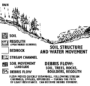
lots of noise and movement of big stuff? Underneath plants, the soil forms
layers. Topsoil, and sometimes a second less organic layer, overlays
weathered bedrock -- chunks of rocks, boulders, gravel. Bedrock is the
bottommost layer. Rain falls and percolates down through these layers. If
the bedrock is very porous, like sandstone, the rain may seep down into
this layer and move downhill. If the bedrock is impermeable, the water
will percolate down through the soil to the weathered bedrock and move to
stream channels at the base of the slope.
As rain continues to fall, the soil and rock
layers become saturated. The water table, the point at which the ground
below is completely saturated with water, moves toward the soil surface.
When the soil is completely saturated it becomes a soupy, muddy mass, and
mud on a hill moves to the lowest point it can reach. As the wet soil
moves downhill, it picks up loose rocks, vegetation, more soil, and
boulders. All these things clank and grind together, creating a huge
ruckus. At the base of the slope, provided the mass hasn't been slowed by
standing trees or houses, the debris may run into a stream channel. This
channel is the path of least resistance to further downhill movement, so
the flow continues to move down the channel. If the mass doesn't run out
of steam, it might reach a river where boulders, rocks, tree trunks, and
soil are carried further downstream.
Living with Landslides
The question remains as to whether we have enough
science to predict when and where landslides will occur. [SEE RELATED REPORT] If we
have enough science, why don't we use it?
Landslides are not a recent phenomenon. A.G.
Warring published a report in 1884 about a landslide near Sitkum, Oregon
that almost killed 20 people. Another landslide near Mapleton, Oregon, in
the 1890s killed a farm family and blocked the Siuslaw River for a short
time.
Until recently, though, not many people lived in
the urban/forest interface. People who did live in these areas had worked
or lived in the forest most of their lives. They probably had a fairly
good idea of where and how to build their houses -- and they knew the
risks.
In the 1970s, the Oregon Department of Geology and
Mineral Industries mapped existing landslides in the state. While areas
that have had previous landslides are more likely to slide in the future,
other factors such as soil, land use, bedrock composition, and hydrology
were not accounted for. These maps cover about 25 percent of Oregon, but
do not assess the potential risk of landslides.
The U.S. Geological Survey has created landslide
risk maps for some regions, and states such as California use hazard maps
in development planning. However, landslide hazard risk maps require
considerable resources: money, time, and information on soil, bedrock, and
slope painstakingly collected in the field. The state of Oregon has sought
funding from the Federal Emergency Management Agency to fund a hazard risk
mapping project, but thus far has not been successful.
Sources:
- Arnold, J.G., and J.R. Williams. 1987. Validation of SWRRB-simulator
for water resources in rural basins. Journal of Water Resources Planning
and Management 113(2): 243-256.
- Coussot, P., and M. Meunier. 1996. Recognition, classification and
mechanical description of debris flows. Earth-Science Reviews 40: 209-227.
- Crozier, M.J. (ed.). 1986. Landslides: Causes, Consequences, &
Environment. Dover, NH: Croom Helm. 252 pp.
- Encyclopedia of World Problems and Human Potential. "Landslides."
1/21/97. Factsheet. http://www.uia.org/uiademo/pro/d1233.htm
- Federal Emergency Management Agency. "What is a Landslide?" 1/21/97.
Factsheet. http://www.fema.gov/fema/fact07.html
- Hurd, C.W. 2/2/97. "Who needs a study?" The Register-Guard.
Op-Ed 2B.
- Jones, J.A., and G.E. Grant. 1996. Cumulative effects of forest
harvest on peak streamflow in the Western Cascades of Oregon. Water
Resources Research 32(4): 959-974.
- Mills, K. 2/28/97. ODF Geotech Specialist. Telephone interview.
503/945-7481.
- Monastersky, R. 1988. Soil may signal imminent landslide. Science News
134(20): 318.
- Oregon Dept. of Forestry Board Meeting. 3/5/97. Testimony by George
Taylor (state climatologist at OSU), Gordon Reed (fish biologist USFS
research lab), and Marvin Pyles (geo-engineer Dept. of Forestry OSU).
- Satterlund, D.R., and P.W. Adams. 1992. Wildland Watershed Management.
New York, New York: John Wiley and Sons, Inc., 436 pp.
- Swanson, F.J., and C.T. Dryness. 1975. Impact of clearcutting and road
construction on soil erosion by landslides in the western Cascade Range,
Oregon. Geology 3(7): 393-396.
- van Asch, T.W.J. 1980. Water Erosion on Slopes and Landsliding in a
Mediterranean Landscape. Ütrecht, The Netherlands: University of
Ütrecht, 238 pp.
- Varnes, D.J. 1984. Landslide Hazard Zonation: Review of Principles and
Practice. France: UNESCO, 63 pp.
- Wang, M.M. 3/4/97. Geological Engineer at Oregon Dept. of Geology and
Mineral Industries. Telephone Interview. 503/731-4100.
- Warring, A.G. 1884. "History of Southern Oregon." Portland, OR.
- Wemple, B.C., J.A. Jones, and G.E. Grant. 1996. Channel network
extension by logging roads in two basins, Western Cascades, Oregon. Water
Resources Bulletin 32(6): 1195-1207.
|

