|
|
| www.wildfirenews.com | Archived 10-08-2004 |
|
WE DO LIKE THEM HELICOPTERSOCTOBER 08 -- GENEVA, SWITZERLAND: "The only things we ever did that made any sense is lighter chainsaws and bigger helicopters." So said an old firefighter, according to Dennis Hulbert, R5 Regional Aviation Officer for the U.S. Forest Service, at this week's Emergency Response Helicopter conference in Geneva, Switzerland. Peter Donaldson, reporting from Geneva for Rotorhub, said comments like that are often a good indicator of the direction a business will take. "Hulbert himself said that helicopters are the best tool for fighting forest fires and that 'a big helicopter gives a pretty good bang for its buck,'" wrote Donaldson. Small, high-performance helicopters can sometimes beat medium machines, according to Donaldson, and the mediums can sometimes beat out the heavies. But according to Hulbert, size really matters. Dropping a large load in one hit, he said, is much more effective than delivering the same quantity over several drops. According to Donaldson, the fatality rate among the old fixed-wing airtankers was three pilots a year for 25 years. That was clearly unacceptable, Hulbert said, and is a major reason that he favors helicopters. The Forest Service encourages crews to report all incidents through the web-based SAFECOM system, and Hulbert said helicopter people are culturally more willing to do this. "I still can't get all my pilots to do it," he said, "and it drives me crazy." The International Heli Trade show ran from October 5 - 7 in Geneva. It's "Europe�s only annual international showcase for the helicopter business," for helicopter operators from civil, military and emergency services to see the latest aircraft, products, and services. More information's online at internationalhelitrade.com
RETIRED OREGON FIREFIGHTER KILLED ON ROGUE RIVEROCTOBER 07 -- SPRINGFIELD, OR: The body of a retired Springfield firefighter and veteran river guide was recovered yesterday from the Rogue, about four miles downstream from where his drift boat flipped on a river trip last week. Ken Robinson, 51, of Marcola, was last seen alive last Thursday afternoon when his boat turned sideways and capsized in a narrow section of the river known as Coffee Pot. His two clients, an elderly couple, were rescued, according to the Register-Guard. The woman reportedly went under with Robinson after the boat flipped, and told rescuers that she felt him push her to the surface. Fire Chief Dennis Murphy with the Springfield Fire Department said Robinson's death left members of the department in shock; Robinson retired last February after a 25-year career with the department. He was a past president of the International Association of Firefighters Local 1395. He was promoted to captain in 1990, and helped develop a number of department initiatives, including the formation of a surface water rescue team. The accident occurred in Mule Creek Canyon, a federally protected section of the Rogue River about 40 miles upstream from Gold Beach. Robinson was an experienced river guide who had led at least 100 trips down the Rogue, and also guided on the McKenzie River and the Middle Fork of the Salmon in Idaho.
POWER FIRE ON THE ELDORADOOCTOBER 07 -- PIONEER, CA: A wildfire that started yesterday in a rugged canyon about 25 miles from the Sierra Nevada foothill town of Jackson has burned 220 acres. Yesterday it put up a huge plume of smoke visible for miles. An AP report said the fire, in Amador County, started near Salt Springs Reservoir and spread quickly. Wendt's Type 2 team is on the fire; it was about 50 percent contained this morning and full containment's predicted for Saturday evening. The fire area is remote with steep terrain, making firefighting efforts and communications difficult. Long-range spotting was a problem yesterday, and a cold front's expected on Saturday. Threatened resources include spotted owl habitat, major powerlines from generating plants, and high-value watershed.
MAN INDICTED FOR STARTING CEDAR FIREOCTOBER 07 -- SAN DIEGO, CA: A federal grand jury indicted a West Covina man on charges he started the largest wildfire in California history last year. The Cedar Fire burned 273,000 acres and killed 15 people. The indictment was returned yesterday, charging Sergio Martinez, 34, with setting timber afire last October and making a false statement. He faces up to 10 years in prison if convicted on both counts. AP reports indicate that Martinez started the fire to signal for help after getting lost on a deer hunting trip on the Cleveland National Forest. The Forest Service cited Martinez for misdemeanor setting of an unauthorized fire. He was released with a warning that he could face felony charges if people were injured or homes destroyed. He was severely dehydrated and borderline delirious when sheriff's deputies in a rescue helicopter picked him up after responding to a call of a lost hunter.
HOTSHOT KILLED BY FALLING SNAGOCTOBER 04 -- KINGS CANYON NATIONAL PARK, CA: A 26-year-old firefighter from Bellingham, Washington, was killed when he was struck by a falling snag. Daniel Holmes with the Arrowhead Hotshots died Saturday after the top of a 100-foot white fir unexpectedly fell where his crew was working on the Grant West Prescribed Fire in the Grant Grove area of Kings Canyon National Park. According to AP reports, about 20 firefighters witnessed the accident, which occurred about 11 a.m. Holmes died while being transported to a helicopter landing zone. His was the park's first firefighter fatality.
COLORADO MAN BILLED $60,000 FOR STARTING WILDFIREOCTOBER 04 -- BOULDER, CO: A target shooter blamed for starting a 35-acre wildfire on the Roosevelt National Forest will be billed up to $60,000 for suppression costs, according to CBS-4 out of Denver. The man was using an explosive target that is banned on national forest land, and he could still face criminal charges.
MAN PLEADS GUILTY TO STARTING WILDFIREOCTOBER 04 -- WAYLAND, MI: A man from Allegan County will pay $974 in fines and do three weekends of community service for starting a huge wildfire near Wayland. Daniel Bartram, 21, pleaded guilty to misdemeanor arson to personal property, according to WOOD-TV in Grand Rapids. Investigators say Bartram was looking for a hole in the ground at a campsite when he lit his lighter to find it and started the foliage on the ground on fire. The fire forced 100 people from a nearby mobile home park.
INSURANCE COMPANIES USING SATELLITE TECHNOLOGYSEPTEMBER 26 -- LOS ANGELES, CA: Got defensible space? If not, don't fib to your insurance agent. Insurance companies are using satellites to identify homes at high risk for fire damage, a practice that has some privacy advocates worried. The concept of satellite inspections came as a surprise to a homeowner north of Sacramento when she received a notice that her home would not be reinsured because it was a quarter-mile away from brush. "I was shocked," said ShereeDiCicco, who lives in Auburn, in the Sierra foothills. "I didn't know insurance companies would, or even could, do such a thing." According to an AP report, First American Property and Casualty Insurance Co. of Santa Ana, which insures DiCicco's home, uses satellite imagery to examine about 10 percent of the properties it insures, mostly in California, Nevada, and Arizona. "It's part of an effort to identify high-risk properties in high-brush areas," said Jo Etta Bandy with First American. California Insurance Commissioner John Garamendi called the practice a serious problem but said he doesn't have the legal right to stop it. "Insurance companies are using satellite imagery and just plain photos to redline vast areas of the state without taking into account the individual circumstances of an individual home," he said. The satellite imagery is reportedly not sharp enough to pick out individuals in their yards, but privacy advocates say it is a concern that must be addressed.
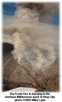
FREDS FIRE AT 850 ACRES
The Freds Fire is burning in steep mountain terrain in the Ventana Wilderness Area about 20 miles west of King City. It was at 25 percent containment last night; Smith's Type 2 team is on the fire, and they put containment at 36 percent early this morning. Full containment is not expected for about a week. Over 700 firefighters are assigned. Five homes are threatened, and the Monterey County Herald reported that one firefighter incurred an eye injury. Most of the fire is burning in chaparral and light grass within the Ventana Wilderness; it's accessible only by handcrews and aircraft. KSBW-TV reported that roads into the Arroyo Seco Recreation Area were closed yesterday. Evacuations of the Arroyo Seco recreation area remain in effect.
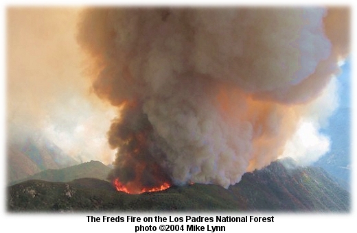 Resources on the fire yesterday included helicopters and airtankers; firefighters expect that the fire will spread up slopes to the north today. The fire started Wednesday near the Arroyo Seco Day Use Area; its cause is under investigation.
CAMP PENDLETON FIRE CONTAINEDSEPTEMBER 23 -- OCEANSIDE, CA: A wildfire burned across more than 100 acres in just two hours yesterday, threatening homes on the Camp Pendleton base near Oceanside; it started about 4:30 p.m. in the Rattlesnake Canyon area of the USMC station and was burning between a base housing complex on one side and a landing strip on the other. More than 100 military firefighters fought the Haybarn Fire, with help from civilian crews and equipment, including four airtankers, five engines, and several helicopters. The Union-Tribune reported that the fire started on the second day of red flag alerts triggered by gusty Santa Ana winds. Firefighters reported humidity levels of less than 15 percent, with live fuel moistures at critical levels. An AP report said the fire this morning was at 120 acres. It was contained by 7 a.m. Another fire in Tulare County was at 310 acres yesterday afternoon; the Hot Springs Fire west of Lone Pine was burning in a remote section of Sequoia National Park. It was ignited by lightning and is being monitored but allowed to burn. The fire's being aerially mapped by GPS every two or three days and is expected to reach about 400 acres. The Freds Fire in Monterey County was 25 percent contained at 100 acres this morning; it's threatening Arroyo Seco structures, including five homes, along Piney Creek. Steelhead habitat in the Arroyo Seco River is threatened, but the fire is burning in a wilderness area and is accessible by handcrews and helicopters. One campground was evacuated.
SANTA ANAS ARRIVE EARLYSEPTEMBER 21 -- LOS ANGELES, CA: With red flag warnings posted, firefighters in southern California are comparing current fire danger with last year's conditions -- just before last year's fire siege. Capt. Mark Savage of the Los Angeles County Fire Department said the extremely dry fuels situation is not going to change unless significant rains occur in southern California. "The fuel that exists right now is at worse levels than what it was last year at this time," he said. Savage told NBC4-TV that the combination of low humidity that accompanies Santa Ana winds and warmer temperatures creates the potential for more dangerous wildfires before the fire season is over. The red flag warning is in effect for the mountains and valleys of Los Angeles and Ventura counties until this afternoon. A fire weather watch is in effect tomorrow from 5 a.m. to 2 p.m. Those counties, according to the National Weather Service, can expect gusty winds and low humidities that will reach critical fire weather thresholds. A red flag warning is also in effect for gusty northeast winds and very low humidities through and below the passes and canyons in San Bernardino, Riverside, and San Diego counties through tomorrow afternoon. Gusty Santa Ana winds are expected to be strongest and most widespread between sunrise and early afternoon, and again during the evening hours between sunset and midnight.
LEFEVRE FIRE CLOSES 89ASEPTEMBER 18 -- JACOB LAKE, AZ: Crews are working a fire today near LeFevre Overlook that has closed U.S. Highway 89A between Fredonia and Jacob Lake. Pushed by winds of 10-15 mph, the fire grew to over 400 acres east of the highway last night. Tanker 21, Tanker 23, and Tanker 48 were all flying the fire this afternoon. Fire managers expect the Lefevre Fire to grow to well over 1,000 acres before it's contained; crews are focused on protecting the highway, on the western boundary of the fire, and Jacob Lake, which is 10 miles south of the fire. Burnouts along the highway are under way. Highway 89A is the major route for visitors to the Grand Canyon's North Rim. Park Service helicopters and BLM engines from Kanab are working the fire, along with the two heavy airtankers. The fire was reportedly human-caused. Whalen's Type 2 team is on the fire, which is burning in piñon-juniper. Nearly 200 firefighters are assigned.
GLIDE FIREFIGHTERS NEED HELPSEPTEMBER 17 -- GLIDE, OR: The Glide Rural Fire Protection District recently received a $5,000 grant from the Northwest Health Foundation to buy a Life Pack 12 monitor/defibrillator. But the total cost is $15,847, according to a report by the Roseburg News-Review, and the district has only until the end of December to raise the balance. Glide, upstream on the Umpqua River from Roseburg, Oregon, is a small community with heavy seasonal traffic of vacationers, flyfishermen, hikers and campers. Glide is near the site where the Apple Fire and the Tiller Fire burned on the Umpqua National Forest several years ago. "If we are able to purchase this equipment it is another step Glide Fire Department has taken to improve the cardiac care it gives the residents of Glide," said Deputy Fire Chief Terry Dean. Donations can be sent to: Glide Rural Fire Protection District, P.O. Box 446, Glide, Oregon 97443. If the extra $10,847 is not raised by the deadline, the department loses the grant.
CONAIR COMPLETES 36th SEASONSEPTEMBER 16 -- ABBOTSFORD, BRITISH COLUMBIA, CANADA: Investing millions of dollars in new technology has helped privately owned Conair Group Inc. stay on top in the aerial firefighting business; this was Conair's 36th season, making it Canada�s longest-serving provider of aerial firefighting services. Conair has a fleet of 46 aircraft, with 150 employees including 68 pilots and 65 maintenance personnel. �We are by far the largest private operator of aerial firefighter fleets in the world,� vice president and general manager Rick Pedersen told Canada's Business Edge. One of Conair�s newest acquisitions is a $2.7-million amphibious Air Tractor AT-802F �Fire Boss.� The Conair fleet at the Abbotsford International Airport includes both airtankers and bird-dog aircraft. Since Conair started operations in 1969, the business evolved into three divisions -- one for fixed-wing operations, another for helicopter operations, and the third an aerospace engineering and manufacturing group. By 2001, the company got out of the helicopter business and set up Cascade Aerospace Inc., for maintenance, repair, and overhaul for third parties. Pedersen says Conair does only aerial firefighting now. The company averages 5,500 hours of aerial fire control each year; they operate and service a fleet of 43 fixed-wing aircraft for fire protection agencies. Conair�s clients include government agencies that rely on private aerial firefighting services. With a small number of potential customers, Conair has learned to develop long-term relationships with its clients -- 36 years working with the government in B.C., 25 years in Alberta, and on and off with the Yukon territorial government since 1972. Alaska has been a client for the past two years, but Pedersen doesn�t see the U.S. as being a lucrative customer at this time. �The U.S. tanker industry is in quite a bit of turmoil. Last year, the federal government terminated all their long-term airtanker contracts,� he said. Conair currently provides forest fire protection services to Alberta, British Columbia, New Brunswick and the Yukon. International customers include the State of Alaska and France.
ARSON SUSPECT IN CUSTODYSEPTEMBER 14 -- MARIPOSA, CA: A man charged with setting a fire that led to the evacuation of dozens of families -- and the injury of two firefighters -- is being held for arraignment in the Mariposa County Jail. Facing 13 counts of arson, Brian Chambers has a history of mental illnesses and of previous arrests related to other fires, according to an AP report; he is also charged with violating parole. The 1,400-acre Old Highway Fire tore through Mariposa County's steep terrain, forcing the evacuation of 50 homes. Evacuation orders were lifted last night, but roads are open to residents only. There are 300 homes and 100 outbuildings threatened, along with about ten commercial properties; the fire was 80 percent contained this morning. Two firefighters were injured; one with a cut to the leg and the other with heat exhaustion. Investigators said Chambers set the fire on Sunday afternoon. He is suspected of starting 12 other wildfires that have occurred since early August, and investigations have confirmed that four of those fires were arson-caused.
TUOLUMNE FIRE KILLS CDF HELITACKSEPTEMBER 13 -- GROVELAND, CA: One firefighter was killed yesterday and six others injured when the Tuolumne Fire turned back on them in a steep and rugged area east of Groveland. The fire was reported just after noon and had grown to over 500 acres by nightfall. An AP report said 24-year-old Eva Schicke was CDF's first female fatality. She had spent four and a half seasons working as a part-time firefighter. According to CDF the other injured firefighters included Capt. Jonah Winger, 29, and firefighters Jon Andahl, 23, Josh Augustin, 29, Thomas Frazer, 25, Shane Neveau, 24, and Jeff Boatman, 29.
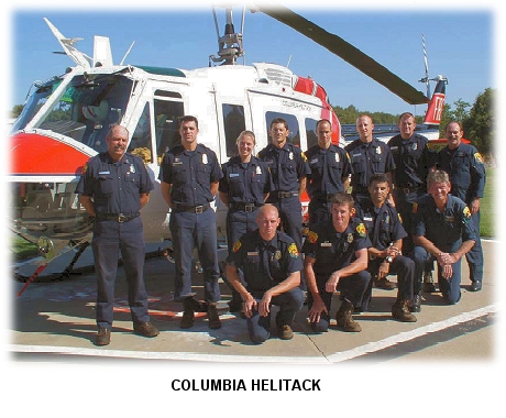 The Modesto Bee reported that all seven firefighters were CDF employees, part of a helicopter crew based at Columbia. Five of the six injured firefighters incurred minor injuries; they were treated at local hospitals and released. One firefighter with moderate injuries was helicoptered to a medical center in Modesto.
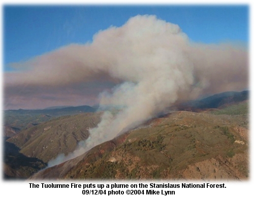 NBC news reported that the fire is moving northeast toward Highway 120 -- the western route into Yosemite National Park. It was 20 percent contained this morning at 800 acres, burning in hardwood slash and heavy brush and timber. Gelobter's Type 1 team is on the fire. Ten homes and the Hetch-Hetchy powerline are threatened, and a campground near Lumsden Bridge was evacuated. An accident investigation team based in Sonora will handle investigation of the burnover.
FIREFIGHTERS INJURED, ONE DEAD ON TUOLUMNE FIRESEPTEMBER 12 -- GROVELAND, CA: Several firefighters were injured today on a fire in a remote area of the Stanislaus National Forest east of Groveland, California. The fire in the Tuolumne River Canyon started shortly after noon today, and was reported at 150 acres this afternoon. Karen Terrill with CDF said the fire was over 500 acres this evening, and moving northeast. News reports late today said seven CDF firefighters were overrun in the Tuolumne River Canyon. One firefighter was killed, one incurred moderate injuries, and five others had minor injuries. An accident investigation team is en route. The fire is on the south side of the Tuolumne River between the river and Cherry Oil Road near Lumsden Camp.
FIREFIGHTERS REMEMBER SEPTEMBER 11SEPTEMBER 11 -- ALL OVER THE COUNTRY, USA: Today marks three years since the tragedies this nation suffered on September 11, 2001. Media outlets across the country have put together an impressive array of features and look-backs, and tributes and memorials abound. The nation won't forget, but many have -- in such a short time -- become numbed. The firefighting community, however, won't ever forget -- some more so than others. Good wishes from the staff at wildfirenews.com to all those who were there -- at the time and especially in the aftermath, and especially to the survivors, and more especially to the national IMT members who were there, and most especially to the FDNY.
"We got sucker punched big time," said Cook. The 11th day of September in 2001 started out like any other day for Cook. "I was on my way to work. Our shift started at 8 a.m., so I was headed there. I got a phone call from my ex-wife. She said, �are you going?� I said, �going where?�" When his pager went off, though, he knew where he was going. For ten days, he and his search dog scoured the rubble. He said he fears America is forgetting, leaving the images and feelings in the past. He says he'll never forget. He says there are scars that will never heal. For the firefighting community, that is true. That is true for the survivors -- who were not just U.S. citizens. This was, after all, an international disaster. Some of the wildland firefighting community -- the crews who labored there in the aftermath, and especially the national incident management teams -- can't possibly forget. The images and the brutal reality of it is something that will never leave them. Thank you, from tens of thousands of us, to the FDNY and the countless others who helped with the aftermath. We won't forget.
NEW SAN DIEGO FIRE PLANSEPTEMBER 10 -- SAN DIEGO, CA: Fire officials this week unveiled a detailed plan for fighting a potentially devastating wildfire on Mount Soledad and evacuating thousands of residents from the vulnerable area. Called the Mt. Soledad Structure Protection Plan, it's the first of at least 14 such firefighting blueprints for communities throughout San Diego. "This fire department needs to be prepared to handle incidents in every corner of San Diego that abuts wildland areas," said Fire Chief Jeff Bowman. The Union-Tribune reported that the goal is to stop a fire from spreading into residential neighborhoods, something a wind-driven fire in the area could do in about 15 minutes. The plan proposes an aggressive air and ground attack at the point of origin, using the I-5 freeway as a fire break to keep such a fire from heading up steep fuels-laden slopes. San Diego police officers and firefighters drew up the plan with help from CDF. It lays out avenues of attack, evacuation routes, and locations for command posts. The area includes light fuels at the base of Mount Soledad, with heavier chaparral above, and slopes as steep as 60 percent. Thousands of vulnerable homes surround the area -- more than 8,500 threatened private parcels, according to the plan. The city Fire-Rescue Department has information online about last year's Cedar Fire, along with sections on safety and disaster preparedness and brush management and weed abatement.
TWO MAFFS UNITS AT KLAMATH FALLSSEPTEMBER 09 -- KLAMATH FALLS, OR: Two military C-130 airtankers are a welcome addition, according to staff at Kingsley Field's airtanker base in southern Oregon. "We are just glad to be hosting them," said Don Chavin, tanker base manager. "It's nice to have some aircraft here." MAFFS tankers 5 and 2 recently arrived in Klamath Falls, and Tim Grantham, military liaison for the Forest Service, told the Herald and News that things have been different this year. Along with the two C-130s came a crew of 50 personnel, including pilots, copilots, navigators, flight engineers, load masters, and a bevy of military and civilian ground support. The two tankers have been in action since May 24. From Peterson Air Force Base in Colorado, the two have been stationed in Arizona, New Mexico, Utah, Idaho, and Washington before arriving at Klamath Falls. The planes and their six-person flight crews can be in the air with a full load of retardant within a half hour. "They are locked and cocked," said Maj. Steve Foss.
RUNWAY FIRE NEARS CONTAINMENTSEPTEMBER 09 -- SAN BERNARDINO, CA: The 1,007-acre Runway Fire at the northern edge of the San Bernardino National Forest was 80 percent contained this morning; nearly 900 firefighters and 11 airtankers and helicopters were on the fire west of Interstate 15 at the Cajon Pass. An AP report said firefighters were anticipating possible thunderstorms forecast for today. "Especially over here, where we didn't get any rain today, fuels are just as dry, and any dry lightning could ignite another fire and then we'd be starting all over again," said incident commander Mark Walker. One home was damaged; major gas lines, jet fuel piplines, electrical transmission lines, railroads, and Interstate 15 are in the immediate fire area. About 500 people were evacuated from the West Cajon Valley hours after the fire started Tuesday afternoon, and 100 more were later evacuated from the Phelan area southwest of Victorville. About seven miles of Highway 138 was expected to reopen this morning.
GEYSERS FIRE COULD CAUSE POWER OUTAGES TODAYSEPTEMBER 07 -- SANTA ROSA, CA: Thousands of northern California homes and businesses could lose power today because of the Geysers Fire in Sonoma County; the fire's burning near a complex of geothermal power plants that provide electricity for the North Coast. More than 20 plants tap subterranean steam piped to generating units across 30 square miles of Sonoma and Lake counties. The 12,525-acre fire was at 85 percent containment this morning with 4½ miles of fireline yet to build. The Sacramento Bee reported that four homes, eight outbuildings, and a dozen vehicles have been destroyed, and that 200 homes and a handful of businesses are still threatened. More than 2,600 firefighters are working on the fire, and they made good progress on line-building overnight. The San Francisco Chronicle reported that crews were cutting line through thick manzanita and timber to stop the northeastern expansion of the fire. Fuels include chamise, manzanita, and ceanothus, making for fast fire spread through heavy second-growth stands of fir and oak. Karen Terrill with CDF said 53 new fires started in California over the 24 hours ending Monday at 4 p.m. Of those, only the Geysers Fire and the 189-acre Hazen Fire in Tehama County were not contained.
GEYSERS FIRE RIPS THROUGH RUGGED COUNTRYSEPTEMBER 05 -- SANTA ROSA, CA: The Geysers Fire six miles northeast of Geyserville, grew from an estimated 1,500 acres around noon yesterday and was only 10 percent contained by last evening. It was almost 9,300 acres by this morning and still at 10 percent containment. More than 1,100 firefighters are on the fire, working in hard-to-reach rugged canyons on the Lake County border. Tanker 25 was flying the fire this morning, and more resources are on order. Scott Sedgley of the Napa City Fire Department told the San Francisco Chronicle that the fire's in some of the most rugged country in California. "Even rattlesnakes carry canteens out here," he said. Firefighters evacuated more than 100 homes along Pine Flat, Red Winery, and Briggs Ranch roads. About 100 homes and 15 commercial properties are threatened. Firefighters this morning said that red flag conditions were a problem, with heavy fuels, steep terrain, and difficult access -- along with record-level low fuel moistures and minimal nighttime humidity recovery. The fire's threatening one of Calpine's geothermal plants; PG&E shut down three transmission lines as a precaution but was able to use alternate powerlines for customers in Sonoma, Marin, and Mendocino counties. Smoke and ash from the fire was darkening the sky as far away as Healdsburg, and Anderson Valley residents said the ash was falling like snow. "It looked like a nuclear bomb went off," said Janet Marshall with CDF. She said firefighters saved three people trapped in a mountaintop house surrounded by fire. A helicopter crew spotted them and touched down, leaving three firefighters behind to make room to carry the civilians to safety. "It was pretty dicey for those firefighters," said Marshall, "waiting for the helicopter to get back." Another fire that started yesterday took off in a steep ravine just east of Sacramento and spread to 750 acres so quickly that it burned over three firefighters, injuring one of them. Sacramento Metropolitan Fire District Capt. Pat Ellis said the fire surprised the crew when the wind shifted; they shielded themselves with a fire shelter, but one was burned badly enough to be taken to a hospital, where he was treated and released. An AP report said firefighters managed to contain 11 fires deliberately set along roadsides in Kern County.
LIGHTNING STARTS A DOZEN COLORADO FIRESSEPTEMBER 05 -- DENVER, CO: A storm that rolled over Colorado set off a dozen wildfires in 24 hours this weekend, but firefighters and rain put most of them out, including the 790-acre Sheep Ranch Fire near Dinosaur National Monument. Nearly a half inch of rain fell there through Saturday. The Denver Post reported that four airtankers and two hotshot crews probably saved several homes near the Sheep Ranch Fire. As the fire season winds down, totals for the state are in the normal range; 30,000 acres have burned thus far, about 10,000 acres less than last year. Colorado's largest fire this year was the Picnic Rock Fire in Larimer County, which burned 9,000 acres in March.
CALIFORNIA FIRE BLOWS TO 9,300 ACRESSEPTEMBER 04 -- SANTA ROSA, CA: The wind-driven Geysers Fire this afternoon was threatening homes, wineries, and major powerlines in Sonoma County and has burned through 9,300 acres of brush and timber. AP reports earlier put the fire's size at 13,000 acres, before its size was assessed by aerial recon. The fire has burned to within a few miles of vineyards in the Alexander Valley along the Russian River. The fire started yesterday near The Geysers, which provides electricity to several counties; the area is crossed by major powerlines, and the geothermal plant has been shut down. Affected counties are temporarily getting power through other routes. The Geysers, the world's largest geothermal power facility, harnesses geothermal steam and provides enough electricity to power 1 million homes in Sonoma, Napa, Lake, Marin, and Mendocino counties. Two-thirds of the plants were shut down and two of three transmission lines are not now being operated, according to Calpine. Pacific Gas and Electric, which owns the lines, has been re-routing electricity from other plants. A San Francisco Chronicle report said the fire went from 400 acres early this morning to 14,000 acres by 2 p.m. Another AP report said the fire threatened 200 homes. "It's blown up," said Dana Cole, a CDF division chief. "Right now, we have no control on the head of the fire." Ash from the fire fell at the Sausal Winery at Healdsburg as helicopters did laps over the vineyard, dipping from nearby lakes to drop on the fire. "Jackrabbits were running out of the vineyard and the geese were flying away," said Sarah Campbell at the winery. Official reports at noon today put the fire at 7,500 acres with about 10 percent containment. More than 100 homes were threatened, along with 15 commercial properties. Evacuations were under way, and about 25 homes on Pine Flat were immediately threatened. Temperatures in the 90s and winds of 20 mph were exacerbating fire conditions. Firefighters said that westerly winds started up about 6 p.m., and they estimated the fire could go at least another 4,000 acres because of that. More than 1,100 personnel are assigned to the fire.
HOT WINDS STOKE CALIFORNIA FIRESSEPTEMBER 04 -- BURSON, CA: A wildfire ignited by a burning motorhome has destroyed 11 homes in the Sierra Nevada foothills, burned more than 2,700 acres in grass, oaks, and chaparral, and forced thousands of people to evacuate the area. The fire is south of Camanche Reservoir in rural Calaveras County, and was 20 percent contained this morning, according to an AP report. CDF said the Calaveras fire forced 3,000 people to evacuate and threatened 1,400 homes and 100 commercial properties. Another fire in Lake County, north of Santa Rosa, is estimated at 400 acres this morning with about 30 percent containment. Tanker 23 has been flying the fire. The Geysers Fire started late yesterday and the cause is under investigation. About a half dozen homes are threatened, as is a Calpine cogeneration facility, with cooling towers and a high-pressure steam transportation system. The cooling towers are valued at $200 million each, and major North Bay power transmission lines are also threatened. Firefighters say the fire also has the potential to disrupt wastewater disposal from Santa Rosa's reclaimed water pipeline. The fire's burning in brush and timber with red flag conditions. Strong north winds, heavy fuels, steep terrain, and difficult access have slowed suppression progress. About 450 firefighters are assigned. A report in the San Francisco Chronicle said a fire near Vacaville, southwest of Sacramento, destroyed a farmhouse and several barns and killed eight horses. Another fire near Davis jumped a highway, burned two homes, and injured three people.
COLORADO FIRE QUICKLY GROWS TO 550 ACRESSEPTEMBER 03 -- ELK SPRINGS, CO: The lightning-ignited Sheep Ranch Fire near Elk Springs is about 30 percent contained this evening; two heavy airtankers flying out of Grand Junction worked the fire earlier today. The fire threatened one home and one commercial property, and destroyed a couple of outbuildings. One residence was evacuated. FAA towers responsible for Western U.S. air traffic were affected when area powerlines just west of the fire were shut down. Erratic gusty winds pushed the fire today, and air operations were shut down for at least two hours because of high winds. Firefighters said the lack of continuous air operations was a problem in suppression of the fire. The fire was pushed by the winds through piñon-juniper, grass, and sagebrush. The Deerlodge/Lily Park road was closed. The fire's expected to gain at least another 100 acres to the west, and firefighters say it could go to 1,000 acres before it's contained. The Denver Post reported that the forecast included winds of 20 to 40 mph with low humidity; dry thunderstorms are also possible across Moffat County. The fire's just east of the Dinosaur National Monument, about halfway between Vernal, Utah, and Craig, Colorado.
BASIN DRAW FIRE OVER 3,000 ACRESSEPTEMBER 02 -- ALADDIN, WY: A fire that started Tuesday in northeast Wyoming was at zero percent containment last night and estimated at just over 2,000 acres. Burning just west of Aladdin, the fire is threatening eight homes, timber, and about 16 outbuildings. Voluntary evacuations were under way last night. Extremely hot, dry, and windy conditions caused extreme fire behavior yesterday, with long-range spotting. A red flag warning has been in effect, and a state Type 3 team was scheduled to take over this morning. The Aberdeen News reported that the fire was ignited by burning garbage near the community of Aladdin near the South Dakota border. By this morning the fire was estimated at 3,200 acres; Tanker 48 and Tanker 21 are flying the fire this morning out of Grand Junction. The fire is the largest this summer in the state of Wyoming.
FIRE RIPS ACROSS NORTH DAKOTASEPTEMBER 02 -- AMIDON, ND: Firefighters in southwestern North Dakota are bracing for a major battle today; a fast-moving grass fire estimated at 4,000 acres is expected to grow to 10,000 acres before it can be contained. KXMA-TV reported that firefighters said flames were as much as 80 feet high this morning. The Logging Camp ranch northwest of Amidon was evacuated, and an incident management team is on order. The Deep Creek Fire was threatening two ranches last night, with temperatures near 100º and wind speeds pushing 30 mph. The fire was crowning in ponderosa pine, with spotting a half mile ahead of the fire. Helicopters and SEATs have been working the fire. The Bismarck Tribune reported that a prescribed burn has been planned for the 6,000-acre forest in the southern ranges of the Badlands for the last couple of years. The Forest Service, along with the Amidon Rural Fire Department, wanted to burn out deadfall to prevent a catastrophic wildfire from taking hold. Prolonged drought postponed the plan. Bowman County Emergency Manager Dean Pearson said smoke could be seen from 50 miles away. "The smoke has been so thick that even some of the fire departments that are responding have a hard time seeing where they are and where they're going," he said. "It's an extremely serious situation."
WANT INSURANCE? |


 SEPTEMBER 24 -- KING CITY, CA: Firefighters made some progress yesterday on a wildfire that has nearly doubled in size on the Los Padres National Forest in southern Monterey County.
 We found but one story to highlight here today, the memories and thoughts of a firefighter from Palm Springs, California. Roland Cook and his search dog Bouts searched for Ground Zero survivors, and he told NewsChannel 3 (
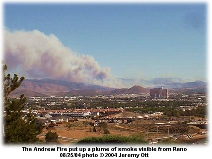 Geiger Grade remained closed Wednesday night.