
|
|
| www.wildfirenews.com | Archived 08-04-2005 |
|
DIRTY FACE FIRE 30 PERCENT CONTAINEDAUGUST 04 -- ISSAQUAH, WA: Despite temperatures in the 90s and heavy dry fuels, crews have reached the 30 percent mark on the Dirty Face Fire in Chelan County. Residents of 75 homes near Lake Wenatchee were allowed to return yesterday after the fire forced evacuations on Monday. The 965-acre fire, on the south slope of Dirtyface Mountain northwest of Leavenworth, came within 100 yards of some houses.
Crews and air resources are working on containment lines today, and structure protection around homes is still a priority. Firefighters are focusing on the area west of the Lake Wenatchee Forest Service office near the avalanche run-out zone, because of rolling debris. If hot rolling debris continues to threaten escape in this area, crews are prepared to conduct burnout operations around the structures. KOMO-TV reported that Gov. Christine Gregoire flew over the fire by helicopter on Tuesday and said August could be a tough month for the state of Washington. "The best thing that's happened here, frankly, is the local folks got on it immediately," she said.
LITTLE IDAHO FIRE SMOKES UP MISSOULAAUGUST 04 -- SALMON, IDAHO: Smoke in the western sky over Missoula last night was not from a Montana fire, according to the Missoulian, but it appeared that a fire on Black Mountain, Blue Mountain, or Lolo Peak was smoking up Missoula. The 3-acre fire yesterday afternoon was about 10 miles west of Lolo Pass; Missoula smokejumpers and two helicopters were on it. The Silver Creek Fire, ignited by lightning on Tuesday, is southwest of Salmon, Idaho, and Svalberg's Type 2 team took it over last night, with about 200 people assigned. It was holding at about 50 acres, and by 8 p.m. it was 50 percent contained. Fire managers said continued aerial support was holding the fireline with bucket and retardant drops. Two heavy airtankers were dropping on the fire out of Missoula today. Across western Montana, new starts showed up yesterday afternoon as the day heated up. On the Lolo and Bitterroot national forests, most of the fires resulted from lightning strikes earlier in the week. Although there were about 18 new fires on the Lolo, most in Mineral County, all were relatively small.
RETARDANT SAVES LOOKOUTAUGUST 04 -- UNION, OR: Rough inaccessible terrain, volatile fuels, and dry hot weather have made the Mule Peak Fire in eastern Oregon a fire to be reckoned with. But protective wrap and a retardant drop have saved the lookout on top of Mule Peak. Management team members told residents at a community meeting in Union Tuesday night that it might be a while before the fire is contained. It's now at 10 percent containment, and the immediate goal is to keep it out of the Minam and Elk Creek drainages. "It's a very difficult fire to get your arms around," said Carl West, IC on the Northwest Oregon Incident Management Team. The 1,090-acre fire's burning mostly within the Eagle Cap Wilderness. The ICP is at the Union athletic complex, with spike camps at Taylor Green and at Buck Creek. More than 700 firefighters are assigned. The La Grande Observer reported that lightning ignited 19 fires on the Wallowa-Whitman last Thursday, and most were caught in initial attack. "Initial attack crews responded and did a very commendable job Thursday," said Forest Supervisor Steve Ellis, "but you never get them all, and this is one they didn't get." He said rappellers went in early on the fire, but were forced to pull back. There's a lot of subalpine fir in the area, and it burns hot. "That's a pitchy, mossy tree," said District Ranger Kurt Wiedenmann, "and once fire gets into it, it flames like a Roman candle." "Subalpine fir is nasty stuff," said John Denne with the Wallowa-Whitman National Forest. "We might be working on this fire for a while because of the fuel types." The fire on Friday threatened the Mule Peak Lookout. The two employees who were stationed there were evacuated by helicopter from the lookout, a wooden building on the 8,679-foot summit of Mule Peak. Crews wrapped fire-resistant material around the building as a precaution, and an airtanker dropped retardant, saving the tower and other buildings. The Baker City Herald reported that smoke from the fire has been visible from the Baker Valley and the Grande Ronde Valley.
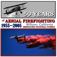
50-YEAR CELEBRATION NEXT WEEK IN WILLOWSAUGUST 04 -- WILLOWS, CA: On August 13 at the Willows Airport, the Mendocino National Forest will host an anniversary day marking the 50th year of aerial firefighting.
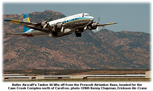
The first drop on a fire was during the Mendenhall Fire, August 13, 1955, on the Mendocino. Vance Nolta flew the Stearman and dropped six loads of water on the fire. It was considered so successful that he worked another fire the very next day. In 1982, the 25th anniversary of the first water drop on the Mendenhall Fire, the USFS honored the original fire pilots with a ceremony and a plaque at the Willows Airport. The anniversary at Willows on Saturday, August 13, will feature displays of vintage aircraft, airtanker demo drops, and historical exhibits. The Forest Supervisor's Office in Willows will also have Mendocino National Forest historical photos and memorabilia on display from noon to 4:00 p.m. The program at the airport will include a fly-by of a Stearman and an N3N cropduster, and a demo by the Redding Smokejumpers is also planned. Static displays of USFS and CDF airtankers and other aircraft are also scheduled. Available online are several commemorative t·shirts featuring anniversary art that includes a Stearman biplane water drop and a retardant drop by Tanker 66. Professional fire photographer Kari Greer donated the photos for the shirts. All profits from the shirts will benefit the AAP memorial fund. The keynote speaker at the anniversary will be Frank Prentice of Chico, one of the original seven pilots in the first airtanker squadron that operated out of the Willows Airport. Other sponsors include CDF, Glenn County, Frank and Lila Prentice, the City of Willows, and the Willows Chamber. For more info email Phebe Brown at [email protected] or call (530)934-1137.
WEED'S MEMORIAL AIR MUSEUMAUGUST 03 -- WEED, CA: The guest of honor at the dedication for the new Siskiyou Firefighter Memorial Air Museum came in early Friday, courtesy of a strong tailwind. This was the last flight for CDF's retiring S-2A airtanker number 94 -- the first of three aircraft planned for the air museum, which will memorialize northern California firefighters who lost their lives in the line of duty. "It's only appropriate that the dangers these people fight on the ground and in the air be recognized," said Siskiyou County Supervisor Bill Hoy. He said the arrival of T-94 was "a great moment," according to the Mt. Shasta News, and he thanked veteran CDF pilots Cotton Mason and Bob Valette for flying the airtanker into retirement at her new home in Weed. "I'm sure we all feel a bit melancholy to see this last landing," he said. Tanker 94 in 1956 was a carrier-based anti-submarine warfare plane; retired in 1980, T-94 was converted five years later for CDF firefighting, and logged nearly 3,800 hours of service as an airtanker. "It's been a good plane for us," said Mason. "Now we're proud to have it here in Weed." Friday's dedication was held one day after the anniversary of the deaths of three firefighters from the Lassen National Forest; Steve Oustad, Heather DePaolo, and John Self -- crew of Lassen's Engine 11 -- died on July 28, 2002 on the Stanza Fire near Happy Camp. Tanker 94 will be joined in the future by an OV-10 Bronco and a HUEY helicopter at the memorial museum. Aviation maintenance technician Cameron Poer took the S-2A down the runway to her tie-down spot. Before he shut the engines down, he ran them at 1200 rpm for a minute; he paused as they roared for the last time. "Listen to that sound," he said. "I kind of hate to turn them off."
HAWAIIAN FIRE EVACUATES 5,000AUGUST 03 -- WAIKOLOA, HAWAII: A fast-moving brushfire on the Big Island of Hawaii has forced the evacuation of nearly 5,000 people, and the town of Waikoloa has been cut off. CBS News reported that the 25,000-acre fire has closed the only road connecting Waikoloa to the rest of the Big Island. Evacuation orders moved 75 percent of the town's 6,500 residents from their homes. The fire's burning along the Kohala Coast on the west side of the island. The Honolulu Advertiser reported that county fire officials last night completed a house-to-house check and reported no homes were burned, but officials told residents to expect smoke damage. The fire's no longer an immediate threat to Waikoloa Village, but roadblocks on Waikoloa Road stopped traffic on the mauka (inland) side of the village, with local traffic only allowed on the makai (seaward) side of the road. Dry weather and winds of 10 to 20 mph with gusts of up to 30 mph made firefighting difficult. Persistent dry conditions led Mayor Harry Kim in May to declare a state of emergency for the entire Big Island after the National Weather Service reported rainfall in some areas was half of normal levels or less. The fire burned in areas used for live-fire training during World War II, and Fire Battalion Chief Curtis Matsui said they decided not to deploy personnel in some areas because of concern about unexploded bombs.
SIX MAJOR FIRES BURNING IN OREGONAUGUST 01 -- SUMPTER, OR: The Burnt River Complex south of Sumpter is 30 percent contained at 618 acres, and includes seven separate fires with two that are active. The fires were started by lightning, and more is forecast for the area. The complex is being managed under Unified Command with the Forest Service and the Oregon Department of Forestry. Almost 600 people are on the complex, including five hotshot crews. The Baker City Herald reported that Thursday's lightning storm rolled through before dawn, rather than in the late afternoon as is typical. Lightning detection maps indicated the first strikes hit eastern Oregon at 3:03 a.m. Thursday, and another 323 strikes were recorded between then and 1:29 p.m. The Dry Cabin Fire southeast of Dayville, also caused by lightning, is 40 percent contained at 270 acres. It's threatening a half dozen structures, and burning in heavy timber with dense understory over extreme terrain in an unroaded area. Just over 300 people are assigned, and fire managers are using helicopter support for transport of personnel and supplies and water delivery. The fire is several miles from any helicopter dip sites, and no water sources are available in the fire area. The Dry Fire northwest of Burns Junction is 30 percent contained at 1,600 acres. Also caused by lightning, the fire made a run yesterday ahead of 45 mph thunderstorm downdrafts, forcing the temporary grounding of air resources. The fire's burning in heavy timber with a dense understory, including heavy dead and down fuels. Active thunderstorms and a lack of air resources are contributing to containment problems. The Mule Peak Fire is about 20 miles southeast of La Grande; it's grown to 800 acres with zero containment. An ICP is being established at the Union Sports Complex, and a spike camp is also being established at the Taylor Green area. The La Grande Observer reported that the fire blew from 5 acres to 500 acres on Friday. Fire managers say it could threaten public access into the Eagle Cap Wilderness; Forest Roads 77 and 7787 have been closed. The fire's burning in subalpine fir and lodgepole in steep country with heavy fuels. Part of the fire is in a wilderness area with limited access for suppression. The fire's in the Sand Pass Creek drainage and the South Fork Catherine Creek drainage, moving east-southeast. The headwaters area of Catherine Creek contains T&E; species including bull trout, salmon, and steelhead. Two people stationed at the Mule Peak Lookout were evacuated by helicopter on Friday. Another fire in the Eagle Cap is burning in the Burger Butte and China Cap area southeast of Union; it's surrounded by rocks and green meadows and is being monitored. The Blossom Complex is about 25 miles northeast of Gold Beach near Paradise Lodge on the north side of the Rogue River. It's 20 percent contained at 1,047 acres and is threatening 16 lodges and residences. The complex includes the Solitude Fire at 128 acres and the Blossom Fire at 911 acres; both are in the Wild Rogue Wilderness. About 560 people are on the fire, including six hotshot crews and nine helicopters. The 2,283-acre Simpson Fire north of Klamath Falls is at 25 percent containment; it was burning actively yesterday on the north and northeast, but crews made good progress tying in and reinforcing control lines; 687 people are assigned. The Double Mountain Fire south of Vale was contained at 24,000 acres. The Skull Springs Fire north of Burns Junction also was contained, at 600 acres, and the Wasson Fire east of Eagle Point was contained at 1,510 acres.
HEAVY FUELS FEEDING MONTANA FIREJULY 31 -- PHILIPSBURG, MT: The Frog Pond Fire southwest of Philipsburg on the Beaverhead-Deerlodge National Forest is at 300 acres and threatening summer homes; crews have installed protective wrap on five structures. Fire information officer Pat McKelvey told the Billings Gazette that the biggest concern was the abundant woody fuels in the area, estimated at 70 tons per acre. Five helicopters were on the fire, which was initial-attacked by 22 smokejumpers. Near Plains, the 2,333-acre Baker Fire was 99 percent contained, and crews were starting rehab of the fire area. The Berry Meadows Fire, which burned nearly 500 acres south of Jackson, was contained earlier this week.
WASHINGTON FIRE BURNS CABINS AND EVACUATES HOMESJULY 30 -- HARRINGTON, WA: The Wall Lake Fire was at 5,414 acres today, burning in sagebrush and grasses; it destroyed three hunting cabins Thursday and forced the evacuation of several other homes. The fire's at 70 percent containment today, burning near the Swanson Lakes Wildlife Refuge in an area of scattered farms, according to KING5-TV. In southwest Oregon, the Simpson Fire near Klamath Falls has burned 1,500 acres, mostly on private land.
WATERTENDER-EATING FIRE PROBABLY IGNITED BY VEHICLEJULY 30 -- DEBEQUE, CO: A fire that destroyed a modular home and a water tender was contained today after burning through about 350 acres of piñon-juniper, grass, and sagebrush. An AP report said the Turkey Track Fire started yesterday south of DeBeque in Mesa County, and fire investigators say it was likely that a vehicle started the fire. A few residents were evacuated but were allowed to return later last night. The Grand Junction Sentinel reported that the Plateau Valley Fire Protection District water tender burned after it broke down about 3 p.m. Winds picked up about that time and caused the fire to flare up and spread east across Black Mountain. At 5:30 p.m. emergency personnel initiated a reverse 9-1-1 evacuation alert to a half dozen homes within a one-mile radius of the fire, but some refused to leave. Local resident Lewis Cox said he was worried about one of his relatives who didn’t want to leave his home. “He said he’d burn in it first,” Cox said. “He won’t come out, and that’s right where the fire is.”
THREE MAJOR FIRES BURNING IN SW OREGONJULY 29 -- KLAMATH FALLS, OR: Two fires near Medford and Klamath Falls and another in the Wild Rogue Wilderness have been pushed by winds and are expected to get more lightning storms; the 1,500-acre Simpson Fire is burning in brush, timber, and grass about five miles north of Klamath Falls, and is 10 percent contained. Fire managers say it could go to 4,500 acres. The Associated Press reported that thunderheads were building over the area. The Wasson Fire, 50 percent contained at 1,200 acres, is 16 miles northeast of Medford. The fire started Tuesday when a truck rolled on the highway. The Blossom Complex in the Wild Rogue Wilderness comprises three fires totaling 625 acres. The Blossom Fire, at 450 acres, is the largest -- burning near Paradise Lodge on the north side of the river. The Huggins and Solitude fires are on the south side of the river. The Curry Coastal Pilot reported that the Huggins Fire was contained, and crews were building line northwest of the Blossom Fire along the Panther Ridge trail. Helicopters dipping from the river were dropping on the fire.
FIREFIGHTERS SPANK ROGUE VALLEY FIREJULY 27 -- WHITE CITY, OR: Fire crews yesterday fought the Rogue Valley’s largest wildfire of the year, which burned more than 100 acres of grass and forestland along Highway 140 about 20 miles east of White City. The Mail-Tribune reported that the fire started when a tractor-trailer rig overturned on the highway early in the afternoon, and winds pushed the fire east toward forest homes and properties -- one of which serves as a tiger sanctuary. "It was burning pretty aggressively between 3 and 4:30 p.m.," said Brian Ballou with the Oregon Department of Forestry. "It was being pushed by a stiff up-canyon wind." Heavy smoke forced the Oregon Department of Transportation to block both lanes of the highway, backing up traffic for a half-mile in both lanes. An airtanker dropped retardant and three helicopters dropped water on the fire. Ballou said crews got worried when they saw flaming debris ignite small fires on the south side of the highway. "For a while it was sending up a lot of whirlwinds of fire that caused a few spot fires across the road," he said -- but crews took care of them before they did any damage. Lake Creek Fire District crews patrolled the area for spot fires near the homes, but the winds died down later in the evening. Ballou said the only structure destroyed was a small tool shed near the highway.
WIND KICKS WASHINGTON FIRE BACK UPJULY 27 -- WENATCHEE, WA: A 2,000-acre wildfire flared back up in the middle of a previously burned area when winds picked up yesterday, but about 30 homes on evacuation notice were no longer considered threatened. Anderson's Type 3 team reported that the fire burned rapidly in light fuels, and the Washington State Fire Mobilzation Act was invoked about 5 a.m. State Patrol Trooper Greg Pressel told the Seattle Times that the fire still threatened several wheat fields about five miles east of Wenatchee. Earlier in the day, the Badger Road Fire was at 50 percent containment, but a new incident management team assessed it at 10 percent. About 100 people are assigned to the fire. Another fire apparently started by a combine in a wheat field burned about 4,000 acres of wheat and grasslands south of Finley on Monday afternoon. More than 100 firefighters and two aircraft responded; an airtanker from Pendleton scooped water from the Columbia River, according to the Tri-City Herald. Another fire in southcentral Washington started on Saturday, also ignited by a combine. Both those fires have been contained. The National Weather Service issued a fire weather watch for today through tomorrow evening for Klickitat, Benton, Franklin, Grant, Columbia and Walla Walla counties.
PLEDGES NEEDED FOR 52-MILE RUNJULY 25 -- LANCASTER, CA: On September 3 Kenneth Perry will set out from Fox Air Attack base at Lancaster for a 52-mile run to raise funds for the Wildland Firefighter Foundation.
An Air Tactical Supervisor for the BLM, Perry decided to make the run for the Foundation's 52 Club, the premise of which is to donate a buck a week to help injured firefighters or those killed in the line of duty and their families. Perry's background includes smokejumping in Alaska and duty with the Fulton Hotshots on the Sequoia National Forest and the Kern County Fire Department. Five years ago he injured his back during a rescue operation in Alaska; even after a couple of surgeries he still deals with constant back and hip pain, but has found that long-distance running doesn't make his back any worse. Perry and the Foundation are asking for pledges on a “per mile” basis in support of the 52-mile run. A referee will confirm the timing and distance; pledges will be sent directly to the Foundation. Spectators and cheerleaders and followers are encouraged. "If anyone happens to be in the area on that day," says Perry, "please feel free to stop by; spectators make great motivators!" To make a pledge in support of Perry's run for the money, check the SUPPORT page on the Foundation website, and note on the form that you're pledging in support of Kenneth Perry's run. Further updates and the run route will be posted on the Foundation's news page at wffoundation.org/news and more information is available from the Foundation at (208)336-2996.
COUNTY JEEP GETS PINK PAINT JOBJULY 25 -- LONGMONT, CO: A fire ignited by lightning on Friday was spotted and quickly smothered by airtankers, and bad luck timing on the part of a county employee resulted in a Jeep painting at the same time. The fire at Heil Valley Ranch flared up at about noon Friday. Airtankers on their way to another fire spotted it and dropped on it, and county firefighters had it contained by mid-afternoon. The Daily Times-Call reported that a P-3 Orion and a SEAT and a lead plane were flying over the area on their way to a fire near Red Feather Lakes when the lead pilot noticed the fire. The tankers dropped on the fire and "deluged" the Jeep of a county open space ranger arriving at the fire. They then headed off to reload and continue their assignment. Boulder County Emergency Services coordinator Jay Stalnaker said the sheriff has told firefighters to take no chances. “The SEAT is going on standby every time, every call,” Stalnaker said. A recent fire in the area temporarily closed public access to Heil Valley Ranch.
FIRE NORTH OF KINGMAN RIPS OVER 11,000 ACRESJULY 24 -- KINGMAN, AZ: The Twin Mills Fire in Mohave County was at 11,000 acres last night and had come within a couple miles of homes. About 25 miles northwest Kingman, the fire's threatenig about 50 homes and over the next couple days could threaten Golden Valley, Dolan Springs, and Chloride. Trent's Type 3 team transitioned management of the fire over today to Philbin's Type 2 team. Extreme fire behavior, thunderstorms, and rough terrain have been a problem; the fire's also threatening critical Big Horn Sheep habitat. Almost 300 people are on the fire, and fire managers say it could go to 22,000 acres before it's contained. Resources include five helicopters, four SEATs, and two heavy airtankers.
PILOT AND TWO JUMPERS INJURED AT LAS VEGASJULY 24 -- LAS VEGAS, NV: How two smokejumpers and their contract pilot survived Thursday's wreck of their twin-engine Aero Commander is a mystery. The plane crashed during takeoff from North Las Vegas Airport, and emergency crews managed a difficult and dangerous rescue. According to the Las Vegas Sun, the pilot and both jumpers were transported to University Medical Center; smokejumper Ron Rucker of Redmond, Oregon, was treated and released. KESQ-TV reported that the other jumper, Margery Kuehn-Tabor of Grangeville, Idaho, has a broken hip and other injuries. The name of the pilot hasn't been released; he underwent surgery at University Medical Center. The 1964 Aero Commander, owned by Commander Northwest Ltd. of Anchorage, Alaska, has been contracted to the Forest Service and other agencies for biological surveys and firefighting assignments for several years. The NTSB and FAA and Forest Service are investigating the cause of the crash. KLAS-TV and KVBC-TV have video clips online.
EDGE COMPLEX GROWS TO 35,000 ACRESJULY 21 -- MESA, AZ: Lineback's Type 2 team last night reported 40 percent containment on the Edge Complex near the Beeline Highway northeast of Mesa. Forty homes are threatened, along with Mud Springs T&E; species habitat and other resources. Temperatures over 100º have been a problem for firefighters -- and at least 18 people have died in the Phoenix area in the last week because of the monsoon-free heat wave. An active flame front on the fire yesterday was headed for Punkin Center, and night shift crews planned to focus on protecting subdivisions. Dozers put in a contingency line to Reno Pass, and fire managers were working on a structure protection plan for Sunflower. About 500 people are assigned to the fire. The Arizona Daily Sun reported today that the dozer line will help protect communications towers on Mount Ord and stop the northward progress of the fire. The Southwest region has more than 16 large fires going, along with several wildland-fire-use incidents. Numerous requests for airtankers and lead planes were placed today with SWCC, and they reported at least a half dozen new starts. Full containment of the Florida Fire, though, is expected by tonight.
IDAHO FIRE EVACUATES COMMUNITYJULY 21 -- BONNERS FERRY, IDAHO: A fire just north of Bonners Ferry prompted Boundary County commissioners to declare a state of emergency yesterday as crews worked a fast-growing fire and a couple dozen residents were evacuated. The fire was reportedly ignited by a train and spread by north winds, according to the Bonner County Daily Bee. The fire was nearly contained by evening after burning about 50 acres, but officials had to shut down one northbound lane of Highway 95. Tankers dropped retardant and a couple state helicopters dropped water on the fire. Idaho Department of Lands incident commander Jim Kibler said reports initially put the fire at 100 acres.
MONTANA'S FIRST BIG FIRESJULY 21 -- BILLINGS, MT: Spring rains this year resulted in heavy grass growth across Montana, and fires started by lightning and pushed by winds have plenty of fuels for rapid growth. Several lightning-caused fires were burning in Montana yesterday; the 5,000-acre Big Horn Fire in southeast Montana, at 50 percent containment, is burning through heavy timber, grasses, sage, and juniper. The fire's threatening many archaeological sites, including historical Gyp Cabin, Big Horn National Recreation Area, and the Crow Tribal Bison Range. The 1,110-acre McArthur Fire north of Winnett was at 40 percent containment. A Type 2 team will take over management today. The fire started on the Charles M. Russell National Wildlife Refuge. A new fire was reported yesterday southwest of Jackson. The Berry Meadows Fire burned almost 100 acres of lodgepole pine in five hours, according to the Missoulian. Fire crews wrapped three buildings on private land along Berry Creek for protection. The Johnny Ridge Fire south of Ennis was contained at 125 acres, and the Beauvais Fire east of Pryor was contained at 300 acres.
CALIFORNIA FIRE THREATENS TRACYJULY 19 -- LIVERMORE, CA: A grass fire near Livermore tonight was officially at 1,500 acres and threatening wind generation systems and the community of Tracy -- and a plutonium storage facility. An AP report said CDF and fire crews from the Livermore National Labs and Livermore-Pleasanton Fire Department and Alameda County were working the fire; KRON-TV put it at 7,000 acres, and the Chronicle tonight had it at 8,500 acres with 50 percent containment. CBS-5 tonight put the fire at 6,000 acres, and one sfgate.com report noted that a "CDF volunteer" said the fire was "a little bit contained" at 5,000 acres. Regardless of the numbers, it's a big fire. The Tesla Fire is threatening at least 500 homes and about 30 commercial properties. At 6:30 p.m. fire managers reported that the fire was burning toward Site 300, a major military and research facility. High temperatures and winds caused the fire to move rapidly, and limited roads in the area are challenging containment efforts. The county incident management team was requested, and another nearby 30-acre fire near Byron was growing, along with a new fire near Altamont Pass this evening. Tracy was considered threatened within hours, along with electrical systems that provide power to local communities from the wind generators threatened by the fire. Livermore Labs is also threatened by the fire. The fire's burning through grass, brush, and oak, and nearly 200 fire personnel were on it tonight. NBC11-TV reported that an operational emergency was declared at the Lawrence Livermore National Laboratory, part of the National Nuclear Security Administration within the Department of Energy, with a staff of over 8,000 people. At least 1,500 lbs. of fissionable plutonium is stored at LLNL. For years, anti-nuclear activists have warned that Livermore's cache of plutonium is a problem. Until last year, Livermore officials were seeking permission to double the amount of allowable plutonium storage on site. Fires on or near DOE lands often involve communications issues between the DOE and firefighting agencies responding with crews. As is common on such incidents, firefighters on tonight's fire were not told details of the area where they're working. "They have things that are very, very sensitive," said Bill Morrison, an assistant CDF chief. "They have structures in here where they do their business," he said. "We don't know what that is." The Chronicle has photos online.
ARIZONA FIRES TAKE OFFJULY 19 -- CAMP VERDE, AZ: The Southwest was busy with heavy initial attack yesterday, with 66 fires reported in the region, most of them caused by lightning. The 500-acre Ridge Complex on the Kaibab National Forest is southeast of Jacob Lake; Reinarz's Type 2 team reported zero containment last night. Four fires within the complex are being monitored, but the Nail Fire was torching, crowning, and spotting, and dozers are cutting lines on it to tie in with roads. The Edge Fire on the Tonto is north of Apache Junction, and Lineback's Type 2 team is assigned. The fire's at 2,000 acres with zero containment, and fire crews say it could merge with the 2,000-acre Valentine Fire, which has burned into the Four Peaks Wilderness Area.
The Oak Fire on the Tonto is northwest of Punkin Center in steep terrain with limited access. It's at 500 acres and zero containment. North of Wickenburg, the Hillside Fire is at 2,000 acres and threatening seven homes. It's also at zero containment, and firefighters yesterday reported extreme fire behavior with high rates of spread, spotting, and running and torching both uphill and downhill. Ranches were temporarily evacuated, with road closures and closure of the Santa Fe Railroad put into effect. East of Bagdad, the SH Ranch Complex is at 2,000 acres with zero containment. It's threatening a half dozen homes, and firefighters reported extreme fire behavior The Indian Hills Fire is near Dudleyville south of Globe, with zero containment at 250 acres. It's destroyed three homes and ten outbuildings and is threatening another 100 homes and about 50 outbuildings. Erratic winds, running, spotting, and crowning were reported. Secondary roads in Dudleyville were closed, and dozers are putting in line on the north and south ends of the fire. Crews plan to burn out from the Indian Hills subdivision. On the Tonto National Forest, the Greenback Fire is at 100 acres with zero containment. It's burning east of Punkin Center, and firefighters reported 30-foot flamelengths. Also on the Tonto and east of Punkin Center, the Salome Fire is at 300 acres with zero containment. It's threatening two homes. The fire spread in all directions yesterday because of thunderstorm activity, and crews today plan to burn out around private property. Also on the Tonto, the Black Fire west of Payson is at 200 acres with zero containment. The Florida Fire on the Coronado is 50 percent contained at 22,000 acres.
CREWS PROTECTING OBSERVATORYJULY 17 -- GREEN VALLEY, AZ: The 21,500-acre Florida Fire east of Green Valley is about 40 percent contained, but crews are still working on keeping the fire from the Madera Canyon and the Smithsonian Astrophysical Observatory Complex on Mt. Hopkins. Nearly 1,000 people are assigned to the fire, including 16 hotshot crews, a half dozen Type 2 crews, eight helicopters, and 27 engines. Parts of the fire had as much as a half inch of rain yesterday, slowing the fire some and reducing the threat to Madera Canyon, but the fire was still very active fire with short crown runs. Strong downdrafts pushed smoke down onto the fire, stopping all air operations for a while. The burnout around Mt. Hopkins was delayed.
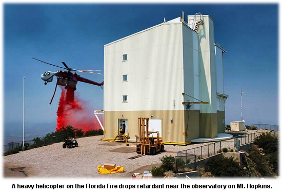 Oltrogge's Type 1 team reported that crews are still working on structural protection and prep work for burnouts in Madera Canyon and around the observatory. The Tucson Citizen reported that the fire's within a mile of some of the world's most sensitive telescopes, but is not expected to cross the ridge and reach the Fred Lawrence Whipple Observatory. The site is a joint venture of the Smithsonian Institution and the University of Arizona; the observatory's on the summit of Mt. Hopkins, the second highest peak in the Santa Rita Range of the Coronado National Forest south of Tucson. The Smithsonian's Whipple Observatory operates a basecamp and a visitors center at Amado, Arizona. Details on road closures and more photos are available from the Coronado National Forest.
WINDS TRIPLE SIZE OF COLORADO FIREJULY 17 -- MANCOS, CO: Pushed by winds generated by a thunderstorm, the Trail East Fire yesterday nearly tripled in size, from 640 acres in the morning to 1,700 acres by 6 p.m. "The wind caught it and just ran with it," said Susan Zornek with Blume's Type 2 team. The Durango Herald reported that mechanical problems temporarily took a large helicopter and an airtanker out of service; fire managers requested another helicopter and more engines in case the fire shifts direction and threatens structures. Seven homes were threatened last night and the fire was at just 5 percent containment. The fire's burning in piñon-juniper southwest of Hesperus, a community southwest of Durango. Plume-dominated fire early in the day was followed by erratic fire behavior later on, caused by low fuel moistures and gusty winds. The fire spread to the south and east, and fire managers said the temporary loss of aircraft support was a critical factor.
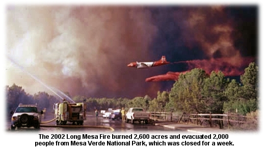 About 215 people are assigned to the fire, which is burning near Mesa Verde National Park. Over the last seven years, five large fires have burned over 28,000 acres -- more than 50 percent of the Park's area -- including the Balcony House Complex and the Chapin 5, Bircher, Pony, and Long Mesa fires.
CONTACT FIRE UP AND RUNNIN'JULY 16 -- JACKPOT, NV: A 1,000-acre fire about 20 miles south of Jackpot on the west side of Highway 93 was 20 percent contained late last night, according to Case's Type 3 team; the fire spread rapidly yesterday and caused a highway closure. The fire's burning mostly in sagebrush and cheatgrass, and crews were challenged with spotting and winds, but they did manage to keep the fire from jumping the highway. Firefighters were expecting winds today of 25 mph with temperatures near 100º and very low humidity. About 60 people were on the fire, and heavy airtankers were hitting it this morning. Nevada's got several other active fires, including the Wilson Reservoir Fire, 20 percent contained at 3,000 acres, and the 300-acre Gold Qurry Mine Fire at 20 percent containment. The About Time Fire, at 20 percent containment, is at 600 acres.
FIRE ON WASHINGTON REZ REACHES 8,000 ACRESJULY 14 -- OMAK, WA: A wildfire burning through timber and sagebrush on the Colville Indian Reservation southeast of Omak was only 10 percent contained last night, and erratic winds pushed the fire on the north and south flanks. "It was not a good day today," said Dave Nee, assistant fire management officer for the Colville Indian Agency. He said the fire made a major run to the south and southwest. The Seattle Post-Intelligencer said two helicopters and an airtanker worked the fire, with eight hotshot crews on order. Young's Type 3 team is managing the West Omak Lake Fire, and they reported that the fire grew from 2,500 acres yesterday morning to about 8,000 acres by 4 p.m. Parts of the fire are burning in steep rocky terrain, but the south and southwest flanks are moving into an area with scattered ranches and farms. Reed and Holloway's Type 2 team are transitioning in.
SoCal FIRE THREATENS 300 HOMESJULY 14 -- RANCHO PALOS VERDES, CA: A 200-acre wildfire whipped by coastal winds threatened 300 homes yesterday when it burned across rugged brushy slopes below hilltop estates of the Palos Verdes Peninsula community. Los Angeles County Fire Inspector John Mancha said flames burned through chaparral and threatened homes. "They got pretty close," he said, "but we had the helicopter water drops on it and prevented it from getting any homes." The San Clemente Fire was 95 percent contained last night. An AP report said about 300 firefighters would remain in the area overnight. Voluntary evacuations were in place but have been lifted.
FLORIDA FIRE JUMPS LINESJULY 14 -- TUCSON, AZ: A fire in the Mt. Wrightson Wilderness area of the Santa Rita Mountains breached containment lines this week and could grow to 20,000 acres. It's threatening the world-renowned birdwatching area and community of Madera Canyon. Canyon residents were evacuated yesterday morning and they met with the incident management team in the evening. A community meeting in Green Valley on Tuesday evening drew over 200 people. Crews did burnous on four divisions yesterday and around the Florida Work Center. Protection measures around the Mt. Hopkins Observatory were also taken. The fire made a significant run along the southern and eastern flanks well into the night on Tuesday, and yesterday it continued to move to the west and south. Raley's Type 2 team is transitioning management to Oltrogge's Type 1 team. The fire, 11 miles southeast of Green Valley, was 20 percent contained last night at 11,375 acres. It's threatening about 10 homes and another 40 structures, and burning in very steep and inaccessible terrain. Firefighters are expecting thunderstorms and shifting winds.
1,230-ACRE FIRE IN MONTANAJULY 14 -- LEWISTOWN, MT: High winds and hot, dry weather pushed a fire yesterday across the Charles M. Russell National Wildlife Refuge 50 miles south of Malta. It was started Tuesday night by lightning. Pallas's Type 3 team said the fire's burning mostly grass and sage and they hope to have it contained tomorrow night. The Missoulian reported that two ground crews and a helicopter had the fire 60 percent contained. Extending 125 airline miles up the Missouri River from Fort Peck Dam in north-central Montana, the refuge covers 1.1 million acres, including the 245,000-acre Fort Peck Reservoir. The refuge includes native prairies, forested coulees, river bottoms, and badlands often portrayed in the paintings of Charlie Russell, the Western artist for whom the refuge is named.
50 YEARS OF AERIAL FIREFIGHTINGJULY 13 -- WILLOWS, CA: On August 13 at the Willows Airport, the Mendocino National Forest will host an anniversary day marking the 50th year of aerial firefighting. The Associated Airtanker Pilots' AAP online store has available several commemorative t·shirts featuring anniversary art that includes a biplane water drop and a retardant drop by Tanker 66. Professional fire photographer Kari Greer donated the photos for the shirts. All profits from the shirts will benefit the AAP memorial fund. By request, two new shirts were added today -- a women's tank top with anniversary art on the back, and a long-sleeve t·shirt with anniversary art on the front and a tanker drop photo (also by Kari Greer) on the back. The shirts and the anniversary day at the Willows Airport honor the original flyboys of aerial firefighting in a tribute to 50 years of fighting fire from the air. In 1955, local pilots Floyd and Vance Nolta, of the Willows Flying Service, successfully modified a Stearman biplane to drop water on fires. Airtanker number 1 was in business. The first drop on a fire was during the Mendenhall Fire, August 13, 1955, on the Mendocino. Vance Nolta flew the Stearman and dropped six loads of water on the fire. It was considered so successful that he worked another fire the very next day. In 1982, the 25th anniversary of the first water drop on the Mendenhall Fire, the USFS honored the original fire pilots with a ceremony and a plaque at the Willows Airport. The one surviving member of that group, Frank Prentice, will attend the anniversary at Willows on August 13, which will feature displays of vintage aircraft, airtanker demo drops, and historical exhibits. Other sponsors include CDF, Glenn County, Frank and Lila Prentice, the City of Willows, and the Willows Chamber. For more info email Phebe Brown at [email protected] or call (530)934-1137.
ARIZONA FIRE KEEPS MADERA CANYON CLOSEDJULY 12 -- GREEN VALLEY, AZ: The Florida Fire on the Coronado National Forest didn't grow much today, but is still at minimal containment; fire managers, though, say they hope to have it contained by Friday evening.
"The containment lines encompass such a large area because of steep terrain," he said in an AP report. "The lines were built where we can build them." The Florida Fire (which, by the way, is pronounced "flo·REE·da") is about 11 miles east of Green Valley in the Mt. Wrightson Wilderness area of the Santa Rita Mountains on the Coronado National Forest. Started by lightning on July 07, the fire's burning at about 8,000 feet elevation and was at 1,850 acres this morning. KOLD-TV reported that ten hotshot crews are on the fire, along with six T2 crews, a couple of T1 helitankers and four other helicopters, 15 engine crews, and three heavy airtankers. Crews today were working on aerial burnout operations, along with more structure protection in Madera Canyon. The incident management team had a community meeting scheduled for this evening at the Green Valley Recreation West Social Center. All public access to the Madera Canyon Recreation Area on the Coronado is restricted. Temporary road closures remain in effect while firefighting crews are in operation, including the Gardner Canyon Road and Greaterville/Box Canyon Road. Temporary trail closures also remain in effect. Fire managers have been using heavy air attack on the fire. 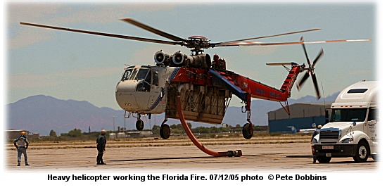 All the metal flying around in the sky is good news for Luis Calvo, owner of the Chuparosa Inn in Madera Canyon. "It kind of looks like there's a volcanic eruption out there," he told the Arizona Daily Star over the weekend. "The drone of airtankers and helicopters … they're working it, that's for sure," Calvo said. Though the fire was still five miles from Calvo's bed and breakfast operation, he said he wasn't worried, and guests and visitors were still coming in. "The main thing is we do have confidence in the Forest Service," he said. KVOA-TV reported that the fire is a few miles from the Santa Rita Experimental Research Range -- the oldest in the world. The University of Arizona works from there on ecosystem analysis. The research unit was founded in 1903 and administered by the USFS till 1987, when the University of Arizona College of Agriculture took over administration. Meanwhile, the Sunflower Fire in Greenlee County northeast of Clifton has grown to 570 acres tonight. Lever's Type 3 team said it was burning on steep terrain with limited access, and could approach 2,500 acres by the time it's contained. It's burning in mesquite, grass, and piñon-juniper; the fire's being monitored. The Tucson Citizen has a good slide show of the Florida Fire online. The paper also reported that the delayed monsoon season this year might amount to the "nonsoon" if rains don't happen soon. Temps are predicted to break today's record high of 109º and Tucson could set the city's record for most consecutive days with a high of 100º or better. The mark is 39 days, set back in 1987, but that record could be beat on July 23 if the Southwest doesn't cool down.
RATTLESNAKE FIRE MEMORIAL DEDICATEDJULY 12 -- ELK CREEK, CA: On July 9, 1953, a brushfire was reported in Grindstone Canyon northwest of Elk Creek on the Mendocino National Forest. The Forest Service requested the volunteer fire crew at the New Tribes Mission, about 25 miles south of the fire. The crew responded, and the arson-caused fire was mostly contained that evening. But the missionary crew was sent down into the canyon in the evening to work a spot fire. About the time they sat down for their supper in the steep brushy canyon, the wind shifted with what was to become known as a killer weather phenomenon. The fire jumped lines and roared down the canyon after them. A firefighter higher up on the slope tried to warn them to get out. Nine of them clawed their way upslope and escaped the path of the fire. But the 15 firefighters who tried to run down the canyon to a road below were burned over. Fourteen firefighters from the New Tribes Mission and one Forest Service employee from the Mendocino National Forest died on the fire. Studies of the fire in the last 50 years have led to changes in safety and training and tactics in wildland firefighting, and the site and its story have been used for years in wildland firefighting safety training.
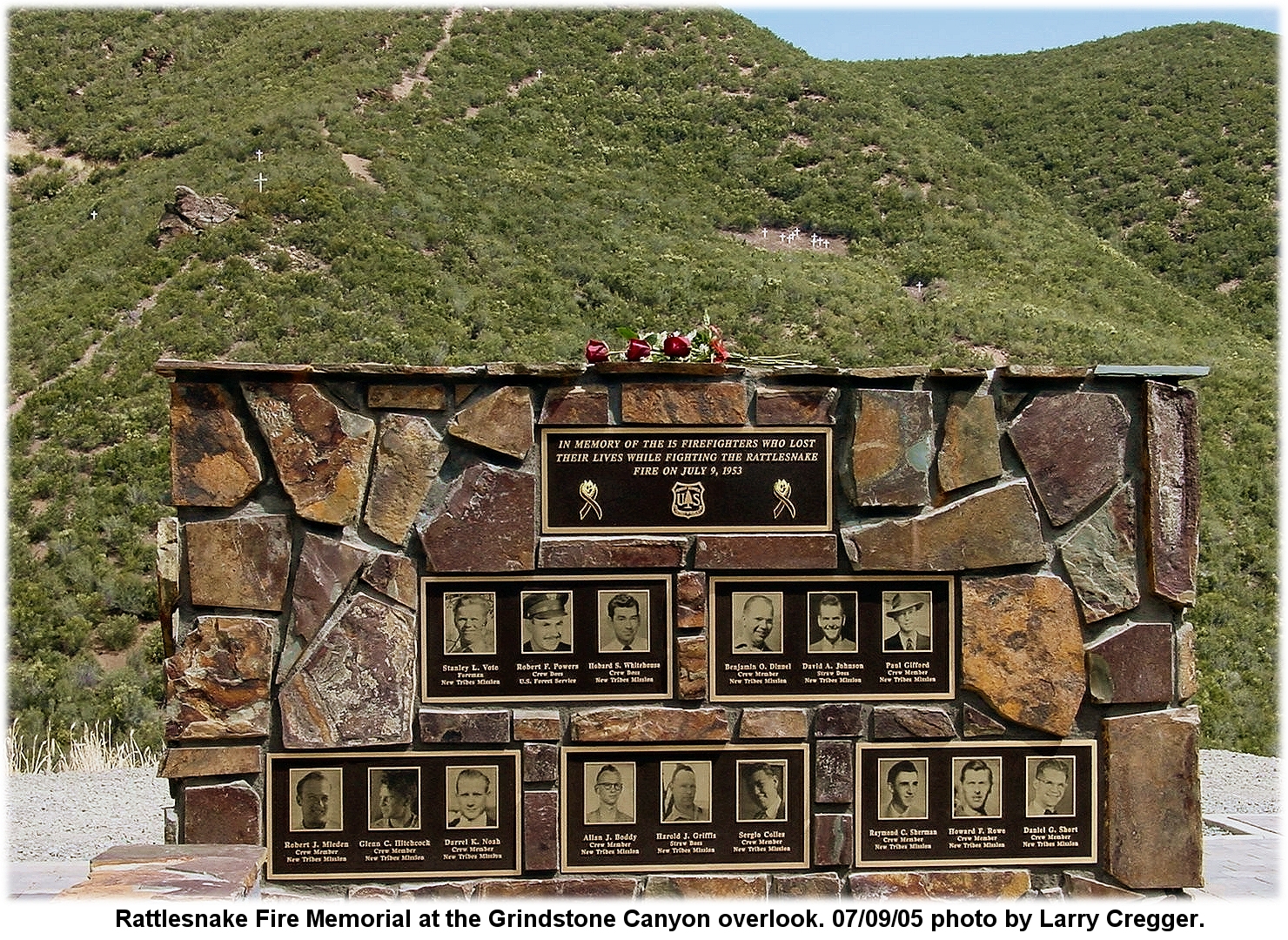 On July 09 the newly developed Rattlesnake site was dedicated. It overlooks the fatality site in Grindstone Canyon, and includes exhibits describing the tragic fire. The Chico Enterprise-Record reported that some of the 300+ people who showed up for the day included some who came to pay respect to the memories of their fathers who were killed in the canyon fire 52 years ago. Ruth Rowe, the daughter of Hobard Stanley Whitehouse, was just four years old when her father lost the race on the ridge. She and her sister, Ilene Backes, came from Wisconsin for the day. One survivor of the fire, Duane Stous, showed up, along with family members and friends from as far away as Arizona and Ecuador and firefighting crews from Willits, Truckee, El Dorado County, and Glenn County -- and of course the Mendocino Hotshots. The overlook project was headed up by Jim Barry, Grindstone implementation officer on the Mendocino. He told the crowd the idea came from a similar overlook he'd seen in Colorado. Barry said the fire was part of what prompted a 1957 Forest Service task force to analyze how similar fire fatalities could be avoided. The 1955 Rattlesnake Fire history is instrumental in wildland fire safety training today.
WEIRD HOT SPOT ON THE LOS PADRESJULY 12 -- SANTA BARBARA, CA: A strange and unexplained hot spot the size of two football fields has started at least one brush fire, and is producing temperatures above 400 degrees at the ground's surface, according to a report by CBS 5 News. It's about 15 miles north of Santa Barbara, in the Dick Smith Wilderness area on the Los Padres National Forest, and was discovered by crews on a fire last summer who said they saw fissures in the ground emitting a lot of heat. The source of that fire was traced to intense heat from the ground itself. USGS hydrologist Robert Mariner found temperatures of 583 degrees in fumerals -- steam vents -- about 10 or 11 feet below the surface. That's hot enough to ignite wood. KRON-TV said a recon flight and thermal infrared showed the size of hot spot is about three acres. The hottest place was 11 feet underground, at 584 degrees. No oil or gas deposits or vents have been located in the area, and there are no significant deposits of coal. Geiger counter readings are normal for radioactivity, and there is no evidence of explosions or volcanic activity. "There's just no reason to have temperatures in fumerals that hot, unless you are dealing with a volcano," said Mariner. But it's not a volcano. One theory is that a landslide in the area could have exposed a combination of rocks or minerals and triggered some kind of chemical reaction. Another possibility is that an earthquake fault could be the source of the heat.
ARIZONA FIRE AT 1,850 ACRESJULY 11 -- GREEN VALLEY, AZ: A fire in the Santa Rita Mountains south of Tucson has grown to 1,850 acres today, and fire managers say it could go over 18,000 acres by the time summer monsoons arrive.
The Tucson Citizen reported that Madera Canyon has been closed because of heavy fire traffic. The fire today was backing downhill on the north and east and south sides of the fire. Crews are working on structure protection in Madera Canyon and at the Florida Work Center, and major work was done today north from McCleary Peak for 1½ miles to prevent major resource damage and more encroachment into Madera Canyon. Fire managers say the success of these operatons will depend on what the wind does. Challenges to fire crews include very steep and inaccessible terrain with a lack of good control features. Other concerns include smugglers in the area and black bears. Winds today were as high as 20 mph with temperatures in the high 9os and RH between 5 and 8 percent. All public access to the Madera Canyon Recreation Area was restricted as of this morning, and several temporary road closures are in effect. The Mt. Hopkins Observatory and Melendrez Pass communications site are nearby, but as of this evening were not threatened by the fire. A community meeting was held today with Madera Canyon residents about possible evacuations. More info on road closures is available from the Coronado National Forest.
BLACK HILLS FIRE AT 3,200 ACRESJULY 11 -- PIEDMONT, SD: Cool temperatures in the Black Hills helped firefighters northwest of Rapid City yesterday, but the cooler weather is also causing a smoke inversion that has limited the air operations. The Ricco Fire is threatening 300 homes and another 60 structures; it was 5 percent contained this morning; almost 500 firefighters are assigned. Several communities and a half dozen subdivisions are threatened, and Martin's Type 1 team has transitioned in to take over the fire. KOTA-TV reported that the fire's burned at least five square miles. About ten earlier evacuations have been lifted, but Upper High Meadows and the Dalton Lake area are still under evacuation orders. Rolling Hills, Woodland Hills, and lower High Meadows are still on advisory. The towns of Piedmont and Blackhawk are currently restricted to local traffic only. Firefighters Saturday reported the highest temperatures and lowest humidities of the season in the area, but a cold front moving into the area was causing very gusty winds. Steep, rocky, inaccessible terrain and narrow winding roads leading into subdivisons were causing structural protection concerns for firefighters. Area thunderstorms also resulted in erratic fire behavior. The fire's threatening archaeological sites and the South Stagebarn Canyon botanical area. The Black Hills Ntional Forest has video clips online, including some aerial tour of the fire and a bit of air ops.
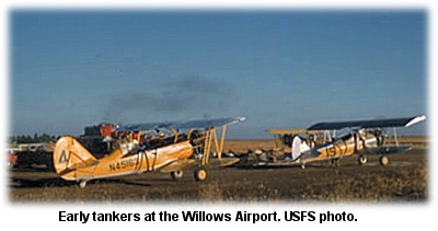
MASON FIRE EVACUATES 5,000 PEOPLEJULY 11 -- BEULAH, CO: The lightning-caused Mason Fire, pushed by shifting winds, has burned across 8,000 acres of ponderosa pine and heavy gambel oak in just three days. Yesterday 5,000 people were evacuated from Beulah Valley and other nearby towns. The fire quadrupled in size, according to the Denver Post, in just a day, and was at 5 percent containment last night. Officials evacuated Vaughn Ranch, the North Creek area, Beulah Valley, and the communities of Red Creek and Savage. Deputies went door-to-door, and reverse 9-1-1 calls were made. The fire's threatening 300 homes and another 120 structures. The towns of Rye and Colorado City are on evacuation alert. "The fire has got the advantage right now," said incident commander Marc Mullenix. He said he sent scouts out across the steep terrain to assess the fire. "There is no safe way to get firefighters in there at all," he said. Last night structure protection crews were trying to save homes in a subdivision along highway 387. They expected the fire to jump the highway, and long-range spotting was a problem. Firefighters reported flamelengths of over 150 feet. The Rocky Mountain News reported that 150 firefighters protected the subdivision near Bears Head Ranch by burning a buffer one-eighth of a mile wide around the homes. "The success at Bears Head Ranch was due to the foresight of fire planning managers who placed resources ahead of time at the ranch," said Barb Timock with the U.S. Forest Service. The plume-dominated fire was moving fast to the south yesterday, threatening Beulah. Erratic winds and storm cells, steep slopes and broken terrain, poor vehicle access, a lack of natural safety zones, and very heavy drought-stressed fuels have contributed to the fire's growth and challenged firefighters. Trigger points were also established to evacuate homes and businesses along Highway 165 north of San Isabel. A trigger point is also in place to evacuate San Isabel. Fire managers say that the fire could continue spreading south and threaten the town of Rye; a trigger point has also been established to evacuate Rye if necessary. Krugman's Type 1 team will take over today. JULY 10 -- WILLOWS, CA: On August 13 at the Willows Airport, the Mendocino National Forest will host an anniversary day marking the 50th year of aerial firefighting. Joe Ely, the fire control officer on the Mendocino in the 1950s, had long been interested in developing the concept of dropping water on wildfires. In July 1955 he talked with several local ag operators about it, and he asked Floyd Nolta, of the Willows Flying Service, if he could do it. Nolta cut a hole in the belly of a Stearman 75 Kaydet, added a one-foot square water release gate, and tried it out. For his historic demo drop, he set the dry grass alongside the Willows runway on fire; his brother Vance flew over it, released the 160-gallon water load, and put out the fire. Airtanker number 1 was in business. The first drop on a fire was during the Mendenhall Fire, August 13, 1955, on the Mendocino. Vance Nolta flew the Stearman and dropped six loads of water on the fire. It was considered so successful that he worked another fire the very next day.
When Forest Service rangers wanted tanker drops on a fire, they radioed the dispatch office at Willows. Charlie Lafferty, the dispatcher, would call one or more of the contracted flying services and let them know where the fire was. Soon, rangers from all across the state were dialing “Willows 80” to ask Joe and Charlie for help. The fledgling Aero Fire Squadron fought 25 fires across California that summer. But these aviation pioneers found that on hot windy days, the water barely made it to the ground. So USFS fire staff tried using a slurry of sodium calcium borate -- but the borate mixture sterilized the ground when it landed. So they tried mixing bentonite with water. When more than one aircraft was needed, Ely would fly in the front seat of a Piper Tri-Pacer piloted by Lee Sherwood. He'd have Sherwood waggle his wings to point out locations where he wanted the tanker pilots to drop. By 1957, the USFS had decided that air attack was a valuable weapon in its fire control arsenal. But the biplanes couldn't carry more than 120 gallons of the heavy bentonite retardant -- and they were useless on project fires. Neither the federal nor state agencies wanted to fund an armada of tiny tankers, so the USFS began working with bigger contractors for larger and faster aircraft. Many Navy TBMs were converted to airtankers that could carry 600 gallons. The original ag pilots who proved that wildfires could be fought from the air were eventually nudged out by the bigger, faster airtankers. Many continued ag work in the area, sowing and spraying the rice fields of the northern Sacramento Valley. 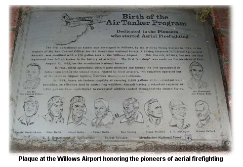 In 1982, the 25th anniversary of the first water drop on the Mendenhall Fire, the USFS honored them with a ceremony and a plaque at the Willows Airport. The sole surviving member of that group, Frank Prentice, will attend the anniversary at Willows on August 13, which will feature displays of vintage aircraft, airtanker demo drops, and historical exhibits. Other sponsors include CDF, Glenn County, Frank and Lila Prentice, the City of Willows, and the Willows Chamber. For more info email Phebe Brown at [email protected] or call (530)934-1137.
MUD LAKE FIRE BURNS INTO CARSON RIVERJULY 10 -- GARDNERVILLE, NV: Fire managers brought out the air power yesterday to knock down a fire pushed by gusty winds southwest of Gardnerville.
A large plume of smoke was visible from the Carson Valley and Reno, and an AP report said the fire was burning along a stretch of the Carson River designated a wild and scenic river corridor. The fire's burning in piñon-juniper, grass, and brush, and is threatening mule deer winter range. The air assault included four S-2 tankers, three SEATs, three helicopters, a large airtanker, and a lead plane. Edgar's Type 3 team said strong winds, rapid rates of spread, spotting, and an above-average fine fuel load were carrying the fire. They closed the Alpine County airport -- an uncontrolled airport -- so fire air operations could be based there. Structure protection is in place to secure a ranch in the fire area. The Reno Gazette-Journal reported that the fire would probably not affect the “Death Ride” annual cycling competition, a 129-mile ride at Turtle Rock Park north of Markleeville.
COLORADO FIRE EVACUATES MOUNTAIN TOWNJULY 08 -- GREENWOOD, CO: Some residents of the town of Greenwood woke up this morning to reverse 9-1-1 calls, and others were roused by a door-to-door campaign by emergency personnel. The Denver Post reported that 50 homes were evacuated and the fire has grown to 250 acres. KRDO-TV reported that many residents were put on notice last night that evacuations were pending. The lightning-caused Mason Fire was at 200 acres last night, burning south of Wetmore on the San Isabel Natioal Forest. Steep slopes, inaccessible terrain, a lack of safety zones, and heavy fuels were challenging firefighters, according to Hessler's Type 3 team. Tankers 48 and 20 flew the fire yesterday, with at least two helicopters, six SEATs, and Tankers 20, 44, and 48 on it this morning. (KOAA-TV has a couple of nice photos.) Almost 100 firefighters were working the fire. Dry thunderstorms, low humidity, and gusty erratic winds are forecast for the area.
ITALIAN CRANE CRASH KILLS OREGON MECHANICJULY 08 -- CENTRAL POINT, OR: A Rogue River man was killed Wednesday when an Erickson Air-Crane crashed during a test flight at a Rome airport. Three others on board were injured. Marty Erickson, a mechanic, died in the crash; mechanic Troy Niemeyer of Eagle Point received minor injuries. Pilot Chris Woods of Washington state and Italian pilot Floriano Finmore also received minor injuries. The helicopter went down shortly after take-off during a hover-controllability check. It was one of four built by Erickson in Central Point for the Italian forest service. Marty Erickson, a long-time employee, was not related to the company’s founders.
RATTLESNAKE FIRE OVERLOOK DEDICATION ON SATURDAY
A new informational and training site overlooks the site in Grindstone Canyon; a new parking area leads to a trail that follows the routes of the firefighters on the Rattlesnake Fire. The Mendocino Hotshots will lead hikes on the trail. Shuttle service will be available from Gillaspy Ranch between 8:30 and 9:45 a.m., returning after the ceremony. John Maclean, author of Fire and Ashes, a 2003 book including the story of the Rattlesnake Fire, will speak at the ceremony and be available for a book signing at Jensen Park in Willows from noon to 4:00 p.m. The 1,300-acre Rattlesnake Fire overran 14 firefighters from the New Tribes Mission and one Forest Service employee on July 09, 1953. The Grindstone Overlook on Forest Highway 7 includes a large boulder marker with the names of the firefighters on a plaque. Near the fatality site in the canyon is a large rock outcrop, called Missionary Rock, atop which stands a large white cross. Maclean's book details the story of the middle-of-the-night unofficial installation of the cross. For more information on Saturday's events, call the Mendocino at (530)934-3316.
SEAT PILOT WALKS AWAY FROM CRASHJULY 07 -- BUCKEYE, AZ: A pilot dropping retardant on the 400-acre Eagle Eye Fire (initially called the Eagle Springs Fire) had a hard landing in his plane yesterday but walked away from it with only minor injuries and called for help on his cellphone. The tanker apparently lost power about 7:45 p.m., according to the Arizona Republic. The pilot put the AT-802 down in desert scrub and he was found walking along the a road. Details of the incident are under investigation. Three SEATs, a heavy airtanker, and a helicopter were working on the fire west of Buckeye, Arizona. The fire is paralleling powerlines, which have been arcing because of the smoke under the lines. The fire last night was 75 percent contained at 1,000 acres.
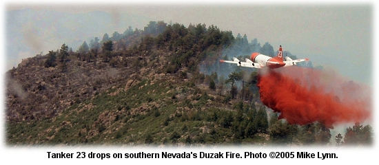
SOUTHERN NEVADA COMPLEX FIZZLING OUTJULY 06 -- MESQUITE, NV: Suwyn's Type 2 team on the Southern Nevada Complex reported containment this afternoon at 508,751 acres. The complex includes the Mesquite Complex, the Duzak and Meadow Valley fires, and the South Desert Complex. Crews today were concentrating on one remaining fire in an uninhabited area of Lincoln County; the Delamar Fire was 40 percent contained in a 240-square-mile area between Alamo and Caliente. The Las Vegas Sun reported that demobe is under way. David Chevalier, info officer on the Duzak Fire, said many firefighters had reached their 14-day limit on the lines and were being released. "We're downsizing considerably and assigning resources to the Delamar Fire where they're needed," he said. "There are still some hot spots in the high country where piñon and juniper are still flaring up, but it's one tree at a time."
 Crews are still working on patrol and monitoring, and they're mopping up hot spots within 200 feet of the fireline. They'll also rehab firelines on slopes greater than 35 percent. The BLM's Ely District will assume command of the complex tomorrow morning.
SOUTHWEST REGION AT PL4JULY 06 -- HOPE, NM: Dry weather and lightning have contributed to a number of new starts across the Southwest in the last few days, with two dozen fires reported several nights ago around Hope, New Mexico, near Alamogordo. Chad Stewart, interagency fire management officer, said lightning caused 24 fires near there Thursday night, but all were contained by midnight. “We did staff up to prepare for it,” Stewart told the Carlsbad Current-Argus. They reported that crews had planned 8,500 acres of prescribed burning last week, but that was put on hold after a needed helicopter from Mescalero sustained minor damage from an old telegraph wire. The Southwest Preparedness Level has been at 4 since June 23, and Texas is posting a 3. Nationally, NIFC put the Preparedness Level at 2 on June 22. The national Multi-Agency Coordination Group (MAC) sets the PL throughout the year to assure readiness of firefighting resources. Factors such as burning conditions, fire activity, and -- especially -- resource availability are used to gauge the levels, which range from 1 to 5 (five being highest). At Level 1 there's little or no large fire activity. When one of the regions reports high fire danger with fire activity and potential for larger fires, Level 2 is declared. When two or more regions are dealing with enough fire to require a major commitment of national resources (such as hotshot crews, heavy airtankers, and Type 1 management teams) then the PL may be bumped to 3 -- but only if extra resources are being ordered through the National Interagency Coordination Center in Boise, national teams are committed in two or more regions, or 275 crews are committed nationally. Staff at NICC explained last week that the fire situation is still well below the established crew committment of 275 -- there were just 186 crews out on July 01. Most of the fires thus far across the West have been of short duration -- two to four days -- with the exception of a few large complex fires. Containment progress has been consistent, and there's been little competition for heavy or medium helicopters, telecommunications equipment, smokejumpers, and many other national resources. The "competition for resources" cited online on some fire-related websites has been primarily for two of the national resources -- hotshot crews and heavy airtankers. Orders for overhead have been regularly filled, with just a little sluggishness on orders for initial attack dispatchers and air attack group supervisors. The national MAC group is assessing the situation on a daily basis. Details on preparedness levels are available online from NIFC and from SWCC.
CAVE CREEK ALSO FIZZLESJULY 06 -- BLACK CANYON CITY, AZ: At 248,310 acres, the Cave Creek Complex in Arizona has just about fizzled out. Information Officer John Bearer told the East Valley Tribune the fire was "pretty much cold." At 90 percent containment now, the complex has run up over $15 million in suppression costs, with 11 homes destroyed and eight injuries to firefighters. But it's almost over now.
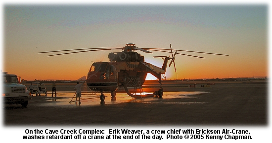 "It looks like it’s pretty well contained," said Bearer. "There’s a few hot spots here and there, but they’re pretty well inside the lines." Resources are being demobilized from the south zone of the fire, and Philbin's Type 2 team has taken over management. On the north zone, crews are cold-trailing and mopping up with air support, and demobe's under way for excess resources. A Type 2 team will transition in tomorrow. The entire Cave Creek Ranger District is closed, except for the Bartlett Lake area and the Mazatzal Wilderness area. The Agua Fria National Monument also remains closed for public safety. Over the weekend, crews did burnout operations on 31 miles of the fire’s 160-mile perimeter. Bernie Pineda, information officer, said that burnouts accounted for about 15 percent -- nearly 40,000 acres -- of the fire's total area. Pineda said everyone working the blaze was surprised it ended with such a small fight. "The fire fizzled out on us," he said. "It didn’t want to play no more."
CALIFORNIA FIRE DOUBLES IN SIZEJULY 06 -- PALMDALE, CA: A brush fire pushed by 20 mph winds was at 300 acres last night, 550 acres this morning, and 1,200 acres by noon today. The Tovey Fire, at 75 percent containment, is southwest of Palmdale and has threatened about 100 homes. Mike McCormick with L.A. County Fire said area homeowners had done some "outstanding" brush clearing and no homes were lost. The cause is still under investigation, according to AP reports. Dozers and hand crews are working on perimeter control. On the San Bernardino National Forest, the Barton Fire is being handled by Kerr's Type 2 team. It's five miles east of Angelus Oaks, burning in beetle-killed timber and threatening historic properties, archaeological sites, watershed, T&E; species habitat, and some private camps and cabins. About 100 homes and two dozen commercial properties were threatened, and precautionary evacuations were ordered yesterday for 21 local camps and campgrounds and 96 historic recreational cabins. Hwy 38 was closed to non-residents for firefighter safety. The fire was 40 percent contained at 100 acres early this morning. The San Bernardino Sun (which has an excellent photo online) reported that more than 1,200 people were evacuated from the area. Five airtankers, two helicopters, eight hand crews, 11 engines, and a dozer are working the fire.
BLACK LINE PROTECTS BLACK CANYON CITYJULY 02 -- BLACK CANYON CITY, AZ: A major burnout has put miles of black between a small Arizona town and the fire that's been threatening it, with thousands of acres burned off yesterday ahead of the Cave Creek Complex east of Black Canyon City. Heavy airtankers, helicopters, and SEATs painted a long line of retardant, crews built line and stripped fuels from homeowners' yards, and hotshots with drip torches combined with aerial ignition sent a wave of flames through the brush and back toward the oncoming head of the fire. The complex this morning is at 214,300 acres and 37 percent containment; resources on the fire include 28 hotshot crews, nine Type 2 crews, 17 helicopters, 73 engines, six dozers, and 15 water tenders. Almost 1,700 people are working the fire. Contingency plans included possible closure of Interstate 17 but it hasn't been necessary yet, and fire managers don't expect any closures over the holiday weekend. The 16,000-acre burnout yesterday may be all that's needed to protect the town.
Dick Fleishman, team information officer, said one of their priorities was to secure the northwestern corner of the fire to protect the town and powerlines, and the big burnout was probably going to do it. "That thing was a thing of beauty," he said. "It's looking really good. When you have no fuel, you have no problem." Some photos of the burnout are online [HERE] The East Valley Tribune reported that 11 hotshot crews worked Thursday building line east of the town. They tore into the fuels around homes in Black Canyon City, clearing chest-high brush from about 15 houses by noon. "It’s really important to give people a little room just in case some fire was to creep over the hill," said Nic Rose, a 24-year-old firefighter with the Klamath National Forest in northern California. Amanda Lee Myers, Tribune reporter, was impressed with the work of Rose and a couple crewmembers. "With the efficiency and speed of machines," she wrote, "the three human bulldozers removed the dry brush from around a propane tank in less than 10 minutes." Firefighters cleared chaparral from power poles and cleared dry fuels from the yards around homes.
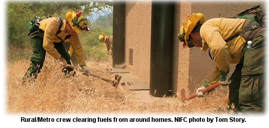 One local resident said firefighters were "working their tushes off." Another resident, Gregory Blocker, said he was grateful that the firefighters had made his home safer. "You’ve done some good work and I appreciate it," he told the crews. Amanda Dedrich, a 19-year-old firefighter from the Klamath, said that was a common response from community members. She said one resident came up and grabbed her hands and thanked her. "I just told him, ‘No problem. That’s my job.’ "
NEVADA'S FORK FIRE OVER 81,000 ACRESJULY 01 -- LAS VEGAS, NV: Suwyn's Type 2 team on the Fork Fire, 50 miles east of Las Vegas, puts containment at 87 percent this morning for the 81,700-acre fire, which is burning in piñon and grass. Better GPS mapping reduced the reported size of the fire, which yesterday was estimated at over 157,000 acres. The fire was ignited by lightning on Tuesday, and has threatened the Lake Mead National Recreation Area, mining claim improvements, Lime Canyon and Jumbo Springs wilderness areas, Million Hills wilderness study area, communication sites, and federally protected desert tortoise habitat. Extreme rates of spread and high flamelengths were reported yesterday at the head of the fire, but crews made good progress with firing operations along the north end of the fire. Goals include containing the fire between two forks of Lake Mead. Krugman's Type 1 team is taking over management of the fire. The fire has contributed to a smoky haze over Las Vegas, and the Las Vegas Sun reported that the county Air Quality and Environmental Management Department issued an ozone alert Wednesday afternoon warning sensitive people to avoid strenuous exercise, especially outdoors, through Friday.
SOUTHWEST UTAH PLAGUED WITH FIREJULY 01 -- ST. GEORGE, UTAH: Firefighters attacked a new fire near St. George last night right after 10 p.m., and a day without lightning came as a relief to the 1,300+ firefighters working on fires across southern Utah. The Diamond Complex north and west of town includes the Diamond Valley, Plateau, Jarvis Peak, Wide Canyon, and Cottonwood Creek fires. The complex is 50 percent contained at 10,500 acres.
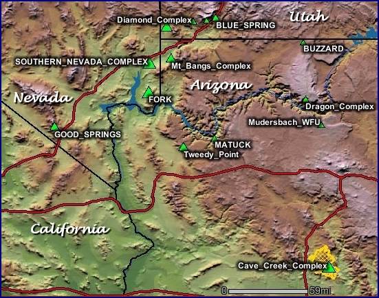 The Spectrum reported that both the Jarvis Peak Fire and the Plateau Fire were contained. More than 1,200 residents were without power Wednesday night because of the fires. The Cottonwood Creek Fire west of the Diamond Valley Fire has burned 324 acres and is being evaluated because of its proximity to the Diamond Valley Fire. The 12,280-acre Blue Springs Fire, 30 miles northeast of St. George, is 70 percent contained. The Duvac Fire, part of the South Desert Complex in Nevada, has crossed the border and burned 22,210 acres in Utah. The 529-acre Harrisburg Fire northeast of St. George is 80 percent contained. The Mt. Bangs Complex south of Mesquite is 80 percent contained at 30,153 acres. The Buzzard Fire east of Fredonia is at 600 acres. The Tweedy Point Fire has burned more than 39,000 acres south of the Utah state line in the Grand Canyon Parashant National Monument. It's 20 percent contained, burning in heavy cheatgrass, sagebrush, piñon, juniper, and desert scrub. Rohrer's Type 3 team transitioned with Thomas's Type 2 team this morning.
CAVE CREEK COMPLEX CHALLENGES RODEO-CHEDISKI FOR STATE'S LARGEST FIRE IN HISTORYJUNE 29 -- CAMP VERDE, AZ: Arizona's second largest fire in history was up to 172,800 acres today, continuing its run north into the Rim Country and worrying residents of small towns north of the fast-moving fire. Crews on the north division hope to keep the fire from crossing the Verde River and threatening the communities of Pine and Strawberry and areas around Black Canyon City and Camp Verde. But the fire today -- with the south zone at 40 percent containment and the north zone at zero percent containment -- was just 12 miles from the trigger point that will start evacuations. Burnout operations are planned on the north zone to keep the fire east of Black Canyon City, which will probably close Interstate 17 again. When and how the fire spreads west will determine the timing of any closures. Aerial firing is also being considered in some areas.
 The ponderosa pines in the area around Pine and Strawberry (the largest continuous stand of ponderosa pine in the world) have been hard hit by beetle kill in a long-running drought, and are vulnerable to a fast-running fire. And the Cave Creek might just be the fire to overtake the record-holding 2002 Rodeo-Chediski, which at 462,159 acres burned its way into history as the largest wildfire ever in Arizona. Last year's 119,500-acre Willow Fire burned near Payson for weeks, and according to AP reports, it was the second-largest fire in Arizona history until the Cave Creek Complex fire surpassed it this week. The Southwest Area MAC group tonight ranked the Cave Creek Complex second on its priority list, right after local initial attack (a typical standard). According to MAC group coordinator Dave Cummings, they'll have another conference call about prioritizing resources for regional fires on Friday. Resources on the fire include 27 hotshot crews from at least six states, along with a half dozen Type 2 crews, 32 engines, four dozers, and eight helicopters. The fire's been repeatedly hit by heavy airtankers flying from the tanker base at Prescott.
 The threat to the Pinnacle Peak powerline is now confined to the northern portion of the fire. Shifting winds, steep slopes, rapid spread, and poor access have frustrated containment efforts, and the fire has burned into the New River Mountains. One of the two Type 1 teams managing the complex, Oltrogge's team has established an ICP in Camp Verde after taking over the northern division, which covers nearly 5,800 acres and currently threatens 4,000 homes and about 50 commercial properties. A joint information center's also been established in Camp Verde. KVOA-TV reported today that dozens of residents at a community meeting last night in Camp Verde were reassured by Incident Commander Dan Oltrogge that he estimates the fire's chances of jumping the Verde River at just 25 percent.
"I hate to say it," he said, "but the stars are lined up. And that's what happened with the Rodeo-Chediski." Lyle said they don't want to scare people, but the fire's spread is unpredictable. "We don't know where the winds will be pushing the fire from hour to hour." Two more community meetings were scheduled this evening, one at the High Desert Park in Black Canyon City and one at the community center in Pine. The Arizona Republic reported tonight that nearly 400 people showed up for the community meeting in Pine. Payson District Ranger Ed Armenta said the national forest around Pine and Strawberry would remain open to the public for the holiday weekend. KPHO-TV reported that more than 200 people packed the park in Black Canyon City this evening to hear what fire managers had to say. They were told that plans include several days of back-burning and cutting line with dozers east of the community. The incident management team is working with the Arizona Department of Transportation on plans for the Fourth of July weekend. The fire is now about seven miles east of Black Canyon City, and from there a wall of smoke is visible. Assessment of threats to homes in Camp Verde is under way, and structure protection is being completed at the Childs Power Plant out by Fossil Creek. Six helicopters and about 40 engines are assigned to the northern division of the fire, with 17 crews including 13 hotshot crews. Crews worked today on improving firelines on the west side of the New River Mountains. The fire was backing down toward the lines, and could be clearly seen from the I-17 corridor in many locations. As of this evening, though, it was still holding west of the Verde River. Traffic in and out of Camp Verde was slowed this morning, according to the East Valley Tribune, when a small brush fire in the median on Interstate 17 just south of Camp Verde caused the closure of the inside lanes on both sides of the freeway.
HOT TIMES AT CEDAR CITYJUNE 29 -- CEDAR CITY, UTAH: The tanker base at Cedar City has been a busy place the last week or so, with airtankers flying in and out on a shifting list of fires around the region. David Ricks, assistant retardant manager at the base, told the Salt Lake Tribune he's been loading tankers more than 60 times a day. Most of the runs this week have been on the Blue Spring Fire, burning on the Dixie National Forest adjacent to Interstate 15. The fire evacuated most of the town of New Harmony Monday night, and has repeatedly closed the highway.
Tankers out of Cedar City also worked the Red Fire and West Side Complex. The 10,000-gallon retardant tanks are refilled six times daily from tanker trucks. "I use about 122,000 gallons of retardant a day," said Ricks. Five heavy airtankers have been flying out of Cedar City, along with six SEATs, three helicopters, and lead planes. Cliff Naveaux, a lead plane pilot, has worked 32 years in fire, and flown a lead plane for the last 18 years. He was a smokejumper, but began flying after he lost a leg in 1987 in an avalanche accident. "At the time I lost my leg I had some aviation experience and wanted to stay in fire," he said. Based in New Mexico, Naveaux flies a twin-engine King Air for the BLM. All available heavy tankers have been flying lately, mostly in the Southwest, and more will come on contract in the next few weeks. Naveaux says the pilots have been busy. "You want to lay the retardant faster than the fire is burning," he said. "If you can't out-gun the fire, then you are playing catch-up."
BLUE SPRING FIRE EVACUATES |


 The anniversary day will honor the original flyboys of aerial firefighting in a tribute to 50 years of fighting fire from the air. In 1955, local pilots Floyd and Vance Nolta, of the Willows Flying Service, successfully modified a Stearman biplane to drop water on fires. Airtanker number 1 was in business.
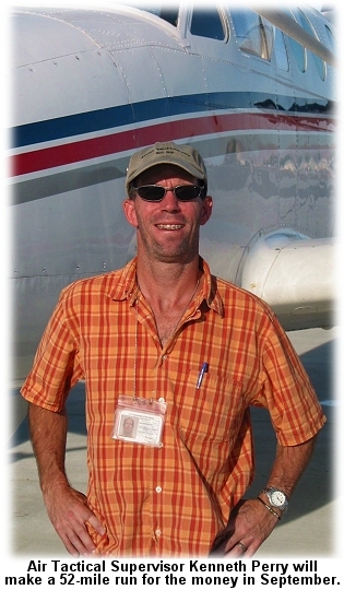 Pledges are being sought by the Foundation in support of Perry's "run for the money."
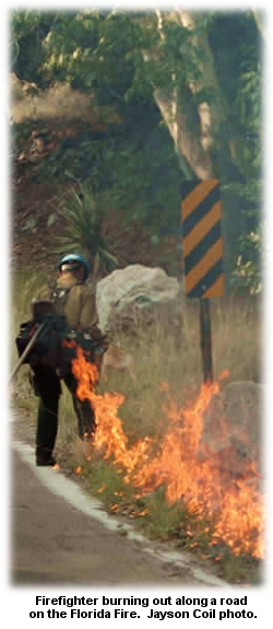
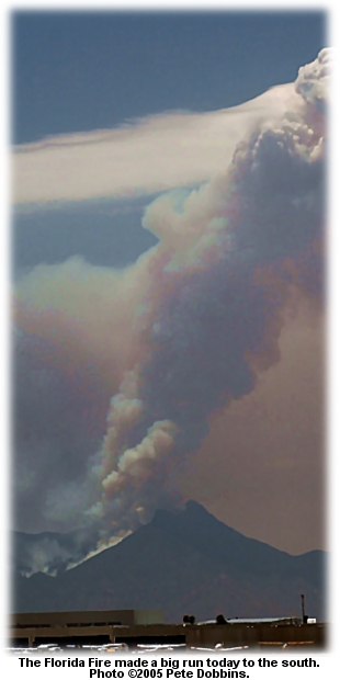 But Dan Bastion with Raley's Type 2 team said the fire could go to 18,000 acres by the time it's controlled.
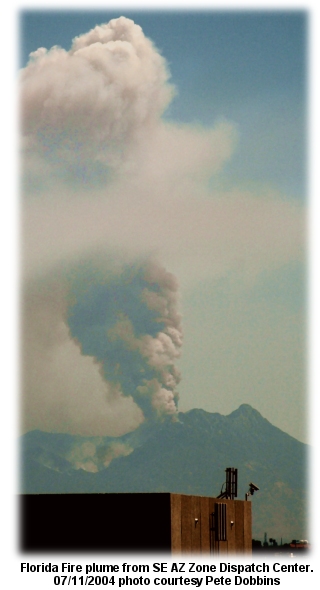 Almost 700 firefighters are on the Florida Fire, including ten hotshot crews, six helicopters, 15 engine crews, and several heavy airtankers.
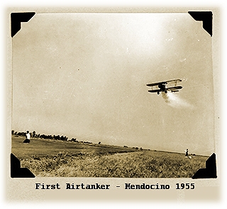 By the summer of 1956, seven biplanes had been modified for firefighting. The original Stearman was joined by several N3Ns -- the primary training planes for U.S. Navy pilots during World War II.
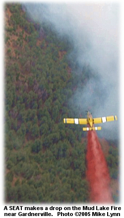 The Mud Lake Fire was burning in heavy brush just northeast of Woodfords, California, and was 20 percent contained at 482 acres last night.
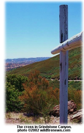 JULY 07 -- WILLOWS, CA: The Mendocino National Forest plans a ceremony at 10:00 a.m. Saturday in memory of the 1953 Rattlesnake Fire, which killed 15 firefighters in Grindstone Canyon near the town of Elk Creek on the Mendocino.
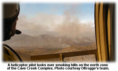 "Obviously the stakes are high," Incident Commander Jeff Whitney told the
 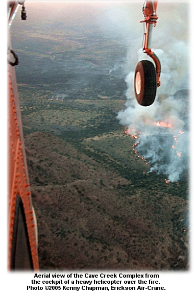 But it could happen, and fire managers know it. Chris Lyle, planning section chief on the fire, told the
 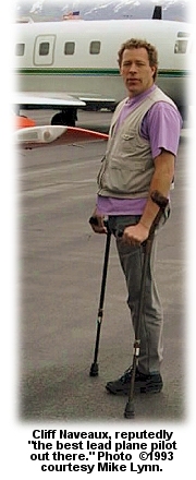 The fire last night was 50 percent contained at 12,260 acres.
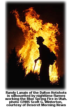
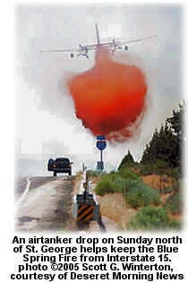