
|
|
| www.wildfirenews.com | ARCHIVED 06-26-2003 |
|
ALBUQUERQUE EVACUATES RESIDENTS AGAINJUNE 26 -- ALBUQUERQUE, NM: Helicopters began the assault on what was probably an arson fire at daybreak today, dropping water over a blaze about five miles north of town. The fire started last night and burned more than 700 acres, according to ABC News, threatening homes and forcing more than 200 people to evacuate. Albuquerque Fire Lt. Lynn Reule said the wildfire was contained this morning but not yet controlled. Mayor Martin Chavez said the evidence suggests the wind-driven fire was not a flare-up of the Atrisco Fire the day before, about a mile to the south. "It has more than one point of origin which is suggestive of arson," Chavez said. Gov. Bill Richardson called up National Guard resources and requested federal help. Hundreds of homes and apartment complexes were evacuated. Chavez said more than 100 homes were "very severely compromised" and 200 to 250 people were ordered to evacuate. Chavez said firefighters would be working strictly structure protection and would not be fighting the fire near the river; much of that area is drought-parched salt cedar and cottonwoods. More information on Southwest region fires is available from the Southwest Area Coordination Center on their Morning Briefing page.
IS YOUR FIRE DEPARTMENT MISSING OUT ON FUNDING?JUNE 25 -- DENVER, CO: Colorado may be losing thousands of federal dollars aimed at fire prevention and suppression because fire departments don't tell the state how many fires they've fought. Less than half the state's fire departments are eligible for federal Fire Act Grants, according to a survey conducted by the state's Division of Fire Safety, but some fire departments have received up to $100,000. According to an AP report on thedenverchannel.com, many mountain districts and small volunteer departments don't report their fires to the state because of a lack of staff or confusing software. "It's been a perennial problem for years and years that we haven't always known exactly how many fires we have," said Bill Wallis, state FMO for the Bureau of Land Management. The state Legislature last year mandated an accurate count of fires -- but provided no money for it. Kevin Klein, director of the Colorado State Fire Chiefs Association, has since 1997 been asking lawmakers for money to count fires. "We don't know how much more we could get, because we don't know exactly how much we're missing," he said. The Denver Post noted that a fire department's reporting of fires is one of the factors used to apportion grant money. "It could be hundreds of thousands of dollars, it could be a million," said Klein. "It would just be a wild guess. That's the problem; we don't know how much more we could get because we don't know exactly how much we're missing." Justin Dombrowski, wildland coordinator for the Boulder Fire Department, said the amount of money passed up certainly reaches into the hundreds of thousands of dollars and likely into the millions. He said if only a handful of the more than 200 ineligible fire departments in Colorado received FIRE Act grants, the funds awarded would total over $1 million. Because there are numerous grant sources, even more money is at stake. As of Friday, 462 wildland fires had been reported in the state, according to Larry Helmrick of the Rocky Mountain Area Coordination Center. But a survey of some departments found that number should be higher. Most of the 97 fires fought by El Paso County's Black Forest Fire Rescue Protection District, for example, were not reported because of confusing software, according to Franklyn Blaha, Black Forest's Emergency Medical Services Coordinator. Besides money, a state forestry official worries that airtankers and other resources could go to other states. Bill Graepler, an assistant forester in the Colorado Department of Forestry, said if they're not showing an accurate count of fires, they could lose the airtanker based at Jeffco. "It could go to Idaho," he said.
FIRE IN ALBUQUERQUE - 1,000 EVACUATEDJUNE 25 -- ALBUQUERQUE, NM: A wildfire that leapt the Rio Grande forced about 1,000 people -- including the mayor's family -- to temporarily evacuate their homes as it burned through 700 acres of brush along the river. The fire caused a power outage that left 16,000 homes and businesses in the dark, and Interstate 40, which crosses the river, was shut down for several hours. Albuquerque Fire Chief Robert Ortega said the fire was probably started by fireworks. ABC News reported that most of the evacuated residents were allowed to return last night; firefighters were still mopping up spot fires this morning. Fire Department Lt. Lynn Reule said about 50 firefighters were on the fire today, down from a peak of 140 yesterday. The fire burned along the west side of the Rio Grande, then jumped the river. "You can see the flying embers, it's scary," said resident Liz Lardizabal. "The whole street in front of our house is solid with fire trucks." The Albuquerque Tribune reported that the fire was not as disastrous as it could have been. The only house that burned was a vacant one under construction. But Chief Ortega said they were just seconds away from disaster. "It's amazing that we didn't lose more structures than we did," he said. "If we didn't have that air support, I'd say we would still be fighting a large-flame fire right now." Mayor Martin Chavez has already accelerated the city's $350,000 annual bosque clearing efforts, pushing the city to finish clearing the 3,000-acre forest in five years instead of ten.
WEATHER'S NOT HELPING ARIZONA FIREFIGHTERSJUNE 24 -- TUCSON, AZ: Firefighters fanned out above and below the Aspen Fire on Mt. Lemmon, but weather is not their friend. And fire managers say it will be at least another week before Summerhaven residents can return to their homes. Larry Humphrey, incident commander, said high temperatures and 25- to 45-mph winds would make it difficult to make significant progress. And msnbc.com reported that the red flag warning issued on Saturday would continue today. "It's going to be another fun day for us," said Humphrey. This is the first time, I think, that we've had six red flag days in a row." Bulldozers yesterday cut a firebreak connecting roads and areas of sparser fuels with an area that was burned over in last year's Bullock Fire, and crews put in line across the fire's southern flank. The fire was about 15 percent contained this morning at 20,850 acres. KFDX-TV reported that the fire's grown to more than 19,000 acres. In the nearby town of San Manuel, it's raining ash, causing breathing problems for elderly residents. The Arizona Republic reported that a lack of money delayed planned forest-thinning work in the areas around Summerhaven; the Coronado National Forest had a depleted budget to pay for projects to reduce hazardous fuels on Mount Lemmon this year. Last year, those projects were budgeted at $234,000; this year, the funding was about half that: $120,000. Environmental groups say the Aspen Fire is a textbook example of what happens when wildland/urban interface areas aren't treated. "Summerhaven proves what the governor was talking about," said Rob Smith of the Sierra Club. "Not enough money is being focused in places that need help." Mt. Lemmon residents had organized into neighborhoods and drawn boundaries around groups of neighborhoods to create 13 treatment areas, according to Barbara Morehouse with the Institute for the Study of Planet Earth at the University of Arizona in Tucson. "The Forest Service and the community were working hard to communicate with each other, and to harmonize their needs and expectations," she said. "When we met with them in March, the community was still exploring alternatives to restore their mountain to its pre-suppression condition. But the work they thought they could reasonably achieve each year was paltry when compared with the magnitude of the problem."
NORTHERN CALIFORNIA ON ALERTJUNE 24 -- REDDING, CA: High winds and low humidity have put north state fire agencies on high alert this week; the National Weather Service issued a red-flag warning yesterday for the Sacramento Valley. The warning, according to the Record-Searchlight is expected to last until Thursday. Northerly winds are forecast to be as strong as 30 mph this week with RH as low as 10 percent "It's the most dangerous type of conditions," said Mike Sawyer, fire prevention officer with the Redding Fire Department. A 610-acre fire in the Vina area in Tehama County was contained in about an hour yesterday. CDF and the Redding Fire Department have canceled a fire training burn north of Turtle Bay that was scheduled for today. The burn is tentatively rescheduled for Friday. The increased fire danger has caused some area fire agencies to increase resources; CDF stations in Tehama and Glenn counties plan to add two additional engines this week.
FIRE IN NEW MEXICO'S JEMEZ MOUNTAINSJUNE 23 -- JEMEZ SPRINGS, NM: Reinforcements were on the way this morning to a new wildfire burning on Virgin Mesa in the Jemez Mountains.
"We had about 75 people on the fire last night, and they made good progress," said Charlie Jankiewicz, a fire information officer with the Santa Fe National Forest. The fire is about three miles from Jemez Springs; thought to be lightning-caused, the fire sent up a plume of smoke visible from Albuquerque. "Compared to last year this time, this fire would have probably been 10 times bigger," said Jankiewicz. The fire's burning in heavy logging slash and there was no estimate of containment this morning. Active fire behavior was reported yesterday with 8-foot flamelengths and some torching; about 300 people were evacuated from a reunion near the incident. Lucero's Type 3 team has been transitioning to Philbin's Type 2 team. The Barro Fire on the Santa Fe National Forest was at 100 acres this morning with zero containment. The fire's burning in ponderosa on steep, difficult terrain with no road access; the fire is strictly a crew and dozer operation with air support. A Type 3 team is on order. Near Fort Union National Monument, another lightning-ignited fire burned about 200 acres of private ranchland. The Monument Fire was at 200 acres with zero containment this morning, burning in mixed conifer and oak. High winds and low RH yesterday caused erratic fire behavior; two firefighters were injured and one was airlifted to a Santa Fe hospital. Pino's Type 4 team is on the fire. John Harrison with the State Forestry Division said a single-engine airtanker that was working on the Monument Fire yesterday apparently hit a patch of dead air, causing it to drop and brush a tree. The tree damaged the plane's flaps and the left landing gear. Harrison said the pilot was able to land the plane at the Las Vegas airport. The Jenny Fire southwest of Beaverhead, New Mexico, was estimated at 210 acres this morning. Burning in mixed conifer, ponderosa, oak, and grass, it exhibited extreme fire behavior yesterday with erratic winds passing through the area. Richards' Type 3 team is on the fire.
FIRE ON MT. LEMMON RAZES HOMESJUNE 20 -- TUCSON, AZ: A fire pushed by 40-mph winds exploded out of the Coronado National Forest yesterday and burned some 250 homes in the community of Summerhaven. "Arizona lost a gem of a community today," said Gov. Janet Napolitano. More homes likely will be lost today, said Larry Humphrey, incident commander on the Aspen Fire, with predicted winds and dry conditions.
The Tucson Citizen reported that the fire was mapped by infrared about midnight at 3,200 acres, and was estimated at 4,000 acres this morning; crews were working to save homes in Soldier Camp. Helicopters and airtankers took off to fight the blaze from the air. The fire, pushed by winds from the southwest and upper mountain turbulence, could double back today, threatening Radio Ridge. Firefighters are keeping a close watch on on the Mt. Lemmon Infrared Observatory west of the fire. Firefighters yesterday tried to keep the fire from burning into Marshall Gulch, from where it could run through Sabino Canyon to hundreds of homes in Summerhaven. But even the hotshot crews were repeatedly pulled back from the fire. "We were a mile away, and we could still feel the radiant heat as the fire passed us by," said Randall Smith, a fire information officer who watched the blowout from across Sabino Canyon. "It was hot enough that it made you look at it like you just walked in front of a heater." Just after noon, a spot fire was confirmed in Marshall Gulch, and crews were withdrawn, including the structure-protection units in Summerhaven. "The slopes were aligned and the drainages were aligned with the prevailing winds of the day," said FBA Mike Davis. "It was set up for some pretty good fire behavior." Bill Hart, fire prevention officer for the Santa Catalina Ranger District, was initially in charge of the fire. He was frustrated by the lack of available airtankers for initial attack. "We definitely needed more air support," he said. "One of the problems -- and it's always a problem when a fire starts -- is finding available resources. We were short because of all the other fires going on. Our first request for air support was satisfied with one airtanker and an escort plane, and later we managed to find a single-engine airtanker." For Humphrey, the Aspen Fire was a study in frustration; his team saved Summerhaven from the Bullock Fire last year. "We managed last year to save the community, and everybody is a hero," he said. "This year, we come in and we lose the town." Residents of Summerhaven have tried to persuade the Forest Service to cut a fuel break around the community, but costs were estimated at over $1 million and fire managers weren't sure it would have helped protect the area from fire. The Arizona Daily Star reported today that the buildings alone on Mt. Lemmon were valued at $100 million. The University of Arizona's Steward Observatory is also threatened, and the value of the buildings and instruments there is estimated at $8 million to $12 million. The Southwest Area was bumped up to Preparedness Level 4 today. The Southwest Area Coordination Center noted this morning that the fire yesterday had flamelengths greater than 200 feet; resources include 13 Type 1 crews, eight Type 2 crews, four helicopters, and 24 engines -- a total of 637 personnel. The University of Arizona webcam has a view toward the fire, and the smoke plume may be visible from the KVOA-TV webcam, too. The Arizona Daily Star site has both a slide show and video clips from the fire.
BOOK REVIEW: FIRE AND ASHESJUNE 18: John Maclean's done it again, only this time he's done it better. His first book, FIRE ON THE MOUNTAIN, was and still is a popular book with wildland firefighters. This one, though, will be a must-own for the summer army of boots-and-nomex firefighters -- and will surely be assigned as mandatory reading in many a fire training course.
Unlike many writers who try writing about wildfire, Maclean makes no lame allowances for readers who might not be familiar with the language and culture of the firefighter. He just explains it for them. His recounting of the 1999 Sadler incident -- in retrospect a problematic compilation of small "oops" decisions that resulted in near-disaster -- is a chilling read when one considers how close it came to being a disaster like South Canyon. His "Short History of Wildland Fire" and glossary of fire terms will prove a useful go-to resource for firefighters -- structural and wildland both -- and for anyone curious enough to read about or write about fire. It's Maclean's reconstruction of the 1953 Rattlesnake Fire, though, that stands as the highlight of the book. It's a can't-put-down story that's finally been accurately researched and told (and illustrated), about a fire that's been a benchmark for safety lessons and fire behavior training for 50 years. Young men and women in fire camps across the West -- and the older ones too -- will be packing this book along in their red bags this summer, and well they should.
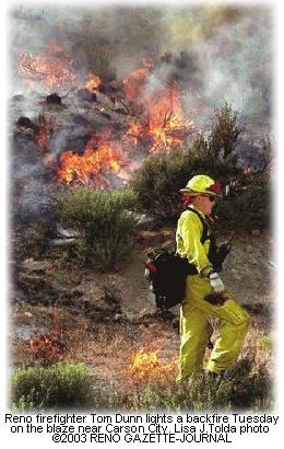
CARSON CITY FIRE CONTAINED
The fire closed U.S. Highway 50 and threatened several homes, according to the Reno Gazette-Journal. Incident Commander Ronan Thornhill with the Nevada Division of Forestry said the fire was human-caused. The fire forced the closure of the highway for about an hour and a half yesterday. Thornhill said it burned through mule deer habitat. About 200 firefighters from across northern Nevada worked on the fire; smoke was visible through Carson and Eagle valleys. Paddy Hardy, Forest Service PAO, said a P-3 and two helicopters dropped about 10,000 gallons on the fire. Though an evacuation was never ordered, plans were in place, and several residents left the threatened area voluntarily. One who did, Voltaire Canyon resident Jo Ann Marzolene, said the smoke was heavy and the winds kept shifting. "My neighbor is up on the roof looking around, and we can see the planes dumping, and all the bulldozers working," said Marzolene. "We always keep our property clear, so I have all my trust in the firemen."
ROAD TO TAHOE CLOSED BY FIREJUNE 17 -- CARSON CITY, NV: A rapidly growing wildfire near the foothills of Carson City closed the highway to Lake Tahoe this afternoon and threatened several homes; some residents have been evacuated. An AP story in the San Francisco Chronicle said lanes were closed in both directions after the fire jumped the highway. "It's growing fast. We have approximately 15 to 20 structures threatened," said Kelli Baratti with the Nevada Division of Forestry. The Reno Gazette-Journal reported that the fire was estimated late this afternoon at between 300 and 500 acres. Sheriff's deputies evacuated two homes in Voltaire Canyon. The Las Vegas Sun reported that flames were visible along the highway and a tall plume of smoke billowed above Carson City, about 35 miles south of Reno. Baratti said more than 60 firefighters were on the fire; eight engines and an airtanker were assigned and more resources were ordered from Redding. Douglas County sheriff's deputies and Nevada Division of Forestry officials said evacuation plans were in place for Voltaire Canyon north of the highway and Clear Creek Canyon south of the highway. The fire's burning in sagebrush and small pines around the highway about two miles west of U.S. Highway 395. The fire grew from first report to 75 acres within an hour, and was estimated at 200 acres an hour later.
MEMORIAL TO HONOR SMOKEJUMPERSJune 17 -- BOISE, IDAHO: The National Smokejumper Association (NSA) will honor 30 smokejumpers killed in the line of duty with a ceremony tomorrow at the Wildland Firefighters Monument at NIFC at 2 p.m. Ron Stoleson, president of the 1,800-member NSA, will present memorial plaques to NIFC and to the Boise-based BLM smokejumpers. "The 30 deceased smokejumpers died in forest fires, aircraft crashes, parachute accidents, and a drowning since the government began delivering firefighters by parachute in 1939," said Stoleson. "We recently discovered that no one had assembled the names of those men or the circumstances of their deaths. Smokejumpers are 'family,' no matter where or when they jumped -- and our association decided it was time to honor those who sacrificed their lives to preserve our nation's precious natural resources." One of the NSA's key programs is preserving smokejumping history. The plaques they'll present tomorrow list the names of the smokejumpers, the years and bases where they trained, and the dates and locations of their deaths. A booklet detailing their lives accompanies each plaque. "We have reasonably complete information on only about half the jumpers killed," said Stoleson. "Each of those men had dreams, aspirations, families, and friends. We want future generations of smokejumpers to be able to identify with them - to know them as something more than mere names on a plaque." Anyone with information on any of the 30 smokejumpers killed in the line of duty should contact NSA researcher Carl Gidlund, 9232 N. Clarkview Place, Hayden Lake, Idaho 83835, or e-mail him at [email protected] More information on the national monument at NIFC is available at wffoundation.org/monument.html and details on tomorrow's memorial are available from Carl Gidlund at (208)772-8299 or Don Smurthwaite at (208)387-5895 or Mike Apicello at (208)387-5460. The NSA is online at smokejumpers.com
PICACHO FIRE ALLOWED TO BURNJUNE 16 -- PICACHO, AZ: A human-caused wildfire that started yesterday is threatening one home near Picacho, but suppression efforts on the fire will be minimal. The Tucson Citizen reported that firefighters spent yesterday burning a perimeter around the Picacho Reservoir fire and monitoring its progress. The fire is eight miles north of Picacho on state land and is about 10 percent contained. KOLD-TV reported that fire managers will let the fire burn over the next few days; it's about 800 acres and it's cheaper to let it burn in a controlled environment than it would be to fight it. The fire is expected to burn up to 1500 acres. Three engines are working the fire and full containment is expected by Friday. In northern Arizona, the Lizard Fire on the Coconino is expected to cross an APS powerline and run into Interstate 40 today. The Lizard Fire and the Mormon Fire are burning parallel to each other about three miles apart; both are burning toward the northeast in dead piñon-juniper, according to the Southwest Area Coordination Center, with lots of spotting and crowning runs. The state patrol plans to close I-40 and reroute traffic around the area if the smoke gets too thick. Thornton's Type 3 team has been activated to manage the fire.
FIREFIGHTER INJURED IN SOUTHERN CALIFORNIA BRUSHFIREJune 16 -- HESPERIA, CA: A firefighter was injured yesterday and airlifted to an area hospital after being hit by a boulder. The Southern California Area Coordination Center reports that the 173 Fire was contained this morning at 80 acres; it started out in grass and light scrub late yesterday afternoon in the Mojave River Valley near Highway 173 and then burned onto the San Bernardino National Forest. The San Bernardino County Sun reported that helicopters and airtankers dropped retardant around the blaze; Mike Snow, division chief for the Hesperia Fire Protection District, said the fire was reported around 5 p.m. It started near a cluster of trailer homes and recreational vehicles east of Arrowhead Lake Road. At about 7 p.m., there was a steady wind of about 10 mph with gusts up to 15 mph. Battalion Chief Randy Clauson with the Forest Service said the river basin creates a "wind-tunnel effect" where winds of 15 to 25 mph are routine. About 200 firefighters, including 30 engines and two hand crews, were working on the fire, along with two helicopters, two airtankers, and a bulldozer. The Casmaila Fire was reported yesterday evening at Hwy 1 and Black Road; the 152 Fire started yesterday just before 3 p.m. on westbound Highway 152 just below the top of the pass. It was contained this morning at 2,750 acres.
PARADISE AWARDED FUEL BREAK GRANTJUNE 12 -- PARADISE, CA: With a $75,000 grant just secured from the Bureau of Land Management, Paradise will soon be closer to creating a ring of sheltered fuel breaks around its vulnerable eastern flank. Butte County Fire Safe Council Executive Director Brenda Rightmyer told the Chico Enterprise-Record the grant will cover phase two of a three-phase project designed to protect Paradise from fires starting in the Concow, Jarbo Gap, and Yankee Hill areas. "A fuel break was completed below Dean Road last year," said Rightmyer. "When a vehicle caught on fire there recently and was fully involved, nothing else burned," she said. The grant was awarded to Paradise after BLM turned down two previous applications. Rightmyer said clearing for the break probably won't begin until late this year or early 2004 and said the contract will probably go to a private company. The Paradise fuel breaks are part of an effort to protect much of the upper ridge and lower foothill areas. Similar grants for fuel breaks and a chipper program were received by Butte County and a group from Yankee Hill.
MEMORIAL TO HONOR GRAYBACK FIREFIGHTERSJune 13 -- LA GRANDE, OR: A memorial service for the wildland firefighters who died a year ago in a van rollover in Colorado will take place on June 21 in La Grande, Oregon. A monument, ordered by Grayback Forestry, will be presented during the memorial service on the anniversary of the fatal accident. According to the La Grande Observer, the monument will become part of a new public park at the La Grande Fire Hall. The five firefighters killed in the accident were Bartholomew Bailey of Corvallis, Daniel Rama of Baker City, Retha Shirley of La Grande, Jacob Martindale of Boise, and Zach Zigich of Twin Falls, Idaho. They were en route to the Hayman Fire in Colorado when the accident occurred. The new public park is being planned by a committee that includes Grayback and La Grande Fire Department Chief Bruce Wiemer and La Grande District Ranger Kurt Wiedenmann. Weimer said no tax money will be spent on construction cost for the memorial park, which is estimated at between $50,000 and $100,000. Grayback will present a donation during the June 21 ceremony. The park will honor structural firefighters, wildland firefighters, and law enforcement officers. Preliminary designs for the memorial park were drawn by students in an art class at Eastern Oregon University. The memorial service is scheduled for 11 a.m. to 1 p.m. at the Blue Mountain Conference Center, 404 12th Street in La Grande. John Schuyler, deputy supervisor for the Wallowa-Whitman National Forest, will speak, as will Mike Wheelock of Grayback and several family members.
ARIZONA BEETLES KILL MORE TREES THAN FIRE DOESJUNE 12 -- PRESCOTT, AZ: Scientists are calling Arizona's bark beetle infestation one of the worst in U.S. history; last year, beetles killed more trees in Arizona than all of the state's wildfires did. The infestation threatens to affect more than 1 million acres of forest by the end of this year. "This is certainly the largest engraver beetle epidemic I have ever seen and probably that anybody's ever seen," said David Wood, a University of California-Berkeley entomologist who has studied beetle infestations throughout the West. "They are really more akin to fire, when you see such massive mortality over a two-year period." Wood surveyed forests near Prescott this spring to help Arizona Public Service Co. figure out how to safeguard about 2,100 miles of powerlines running through beetle-infested areas. The Arizona Republic reports that similar surveys by the Forest Service and the University of Arizona will help calculate the extent of the damage. It's estimated that about 800,000 acres of private, state, tribal, and federal land have been infested, with more than 6 million trees dead. That's up from less than 50,000 acres in 2001. Similar outbreaks are occurring in New Mexico, Colorado, and southern California. Hardest hit in Arizona are forests near Prescott, Crown King, Horsethief Basin, Pine, and Strawberry, as well as wide bands of forest near Flagstaff and Winslow. In some areas, tree mortality is nearing 90 percent. The most immediate threat is fire danger. Gov. Janet Napolitano has asked the federal government for $232 million to reduce fuels trees near towns, highways, and utility corridors. Downed powerlines would create a serious fire hazard, which is why APS commissioned their survey. "We flew the area today and saw a lot of trees that four months ago were green and today are olive," said Mike Neal, APS forestry manager. "That means they're infected. It's definitely spreading." In normal years, the trees would produce enough resin to ward off beetle attacks, but drought has drained them of their defenses. Once beetles infest a tree, it's too late to do anything; the tree will die. Insecticide can be effective in small areas, but it won't work on a forestwide scale. The beetles spread until they run out of trees -- or until the trees regain enough strength to thwart the attack. And Southwestern forests were especially vulnerable when this drought hit -- because the forests are so dense. One way to avoid another infestation is to thin the forests, Wood said, an option that draws quick opposition from many environmental groups. "If we don't kill the trees, the beetles will," Wood said. "It doesn't make any difference where you come down on the political spectrum, it will happen."
MINDEN MEMORIAL SCHEDULEDJune 11 -- RENO, NV: Just after noon last June 17, airtanker pilot Steve Wass, co-pilot Craig LaBare, and flight engineer Mike Davis were killed on the Cannon Fire near Walker, California, about 70 miles south of Reno. Nearly a year later, and almost to the hour, a memorial will be dedicated in their honor at Heritage Park in Gardnerville. The dedication is scheduled for Tuesday, June 17 at noon. Heritage Park is a new park directly across Highway 395 from Sharkey's Casino.
The Reno Gazette-Journal reported that the project was undertaken by the Carson Valley Sertoma Club, a service organization of which Draper is a former member. "As a tribute to their heroism and as a statement of the appreciation and the respect this community has for their sacrifice, the Carson Valley Sertoma is establishing a memorial to these firefighters," said club member Bob Taormina. From a bench in the park, visitors will be able to watch airtankers take off from Minden-Tahoe Airport. The project was organized by Draper and fellow Sertoma member Dave Thomas, owner of a Gardnerville nursery. Thomas, a firefighter, proposed the project to the Sertoma board of directors.
ARIZONA WORKING ON 48,000-ACRE RxFIREJUNE 11 -- DOUGLAS, AZ: That's not a typo. That's forty-eight thousand acres. Coronado National Forest staff are working on about 5,000 acres of the project today in southeastern Arizona. The goal for the Baker Burn is to improve wildlife habitat and rangelands by reducing an invasion of mesquite and other woody species in grassland areas. "This is a reintroduction of fire into a fire-dependent ecosystem," said Doug Hardy, Douglas district ranger on the Coronado.
The Tucson Citizen reported that the Baker Burn will be the largest controlled burn in Arizona history. The project will take eight days to complete and will be managed by about 80 firefighters, including a helicopter with ping-pong balls. About 15,000 acres of the burn is on national forest lands; the rest is state, private, or other federally managed land. The burn will beat the previous record for size; a 22,000-acre burn was done on the Buenos Aires National Wildlife Refuge in May. Also in May, the BLM in New Mexico did a long-planned burn project of 5,000 acres on Ladron Peak north of Socorro.
CLIMATE CHANGE PROJECTS ALTER FORECASTSJune 09 -- CORVALLIS, OR: Computers loaded with weather data and vegetation maps can look over the past century and find the confluences of heat, dryness, and fuel that produced the Yellowstone fires of 1988 and the Tillamook burns of the 1930s. But can they accurately look far enough into the future to allow the U.S. Forest Service to budget scarce firefighting funds, target forest thinning projects and prescribed burning, or even help decide where and when to deploy fire crews and equipment? A team of Forest Service scientists is working to make it so. "Predicting this upcoming fire season is probably not as important as predicting fire seasons out two or three years," says Ronald Neilson, a bioclimatologist at the Pacific Northwest Research Station and team leader on the project. "If you had enough advance notice, you could get out and do pre-fire burning. You could pull the fuel rug out from under it." That would be a huge breakthrough in long-range wildfire forecasting, according to an AP report on Newsday.com "It's in its infancy," says Tim Brown, director of the Program for Climate, Ecosystem and Fire Applications (CEFA) at the Desert Research Institute in Reno. "It's getting very close to starting to have important value." Three years ago, the National Fire Plan began funding wildfire forecasting research. One tool is the National Wildland Fire Seasonal Outlook from NIFC. It was developed from a meeting in February of some 30 meteorologists, climatologists, and fire managers who gathered in Tucson to pool their expertise. They considered winter snowpack, moisture in dead wood, drought, fire history, spring rains, summer lightning patterns, and long-range weather forecasts. The current outlook, according to Rick Ochoa, national fire weather program manager for the BLM, calls for an above-average season, but far milder than last year's. Back in his days on a hotshot crew, Mike Fitzpatrick, intelligence coordinator for the Northwest Interagency Coordination Center in Portland, knew a crew foreman who always said the rain in June would set the season. When Fitzpatrick told that story to Paul Werth, the fire weather program manager looked through 33 years of fire history and noticed that big fire seasons came after a dry winter followed by a dry June. The system was put to the test in 2001. Forecasters spotted a lightning storm moving north through California. Typically, those storms move up the Cascades to Mount Jefferson, then head east toward the Wallowa Mountains. The climate zones showed the greatest fire potential in northeastern Oregon. So fire crews and equipment were shipped to the area before the storms hit. "We were successful in containing all but three of the 200 fires that started," Fitzpatrick recalled. For the next century, the model shows temperatures rising, causing more rain over much of the West. maps of fire regimes and fuel buildups were inserted, and two of the three resulting climate scenarios show a high potential for fire in southwestern Oregon and northern California -- particularly around Lake Tahoe. For all that forecasters can do to calculate fire potential, they still have no good way to foresee the spark that actually ignites a fire, says Neilson. "There are two components -- lightning and people -- both of which are very hard to predict."
ARIZONA FIRE DOUBLES IN SIZEJUNE 09 -- ALPINE, AZ: A wildfire on the Apache-Sitgreaves National Forest doubled in size yesterday, burning in steep and rocky terrain about 15 miles south of Alpine.
Four homes and ten outbuildings are threatened; an AP report in the Arizona Republic noted that the closest home is nearly a mile away. Kvale's Type 2 team is on the fire along with nine Type 1 crews, five Type 2 crews, four helicopters, three engines, a dozer, and a watertender. The fire's burning in the Blue Primitive Area, which is steep and rugged with heavy fuels. The Southwest Area Coordination Center reported 23 new fires in the region yesterday; ten were on the Coconino National Forest. The Mormon Fire southeast of Flagstaff was ignited by lightning on Friday and was reported at 300 acres this morning. It's burning in piñon and is in a confinement strategy -- aerial recon is occurring twice a day. The Blanco Fire west of San Ysidro, New Mexico, which started last Wednesday, has been contained at 640 acres. Crews are mopping up. The Dry Lakes Complex northwest of Silver City is now up to 4,675 acres, and is being managed by Rath's Fire Use team. These fires are being monitored, structure protection for historical sites is in place, and aerial monitoring is occurring.
MISSIONARY RIDGE FIRE: ONE YEAR LATERJune 08 -- DURANGO, CO: By all accounts, last year's Missionary Ridge Fire was an extraordinary fire. The drought conditions, single-digit humidity, steep and overgrown terrain, and high winds combined for the perfect setting for an extraordinary fire. "I don't think there are many firefighters around the country that our fire wouldn't have impressed," said Pauline Ellis, ranger and field manager for the Columbine District of the U.S. Forest Service and Bureau of Land Management. "Once in a lifetime." Creating defensible space around homes does work, and as the Durango Herald reported, some homes were saved because of that work. One home in the Falls Creek subdivision was spared when fire-mitigation work stalled flames at the edge of the property. But a home's survival often depends on nothing more than chance.
The vortex, which Ellis says impressed even the most seasoned federal firefighters, illustrates the extreme behavior of the fire. Towering plumes of smoke -- the tallest at 44,000 feet -- collapsed, throwing heat and embers and starting spot fires a mile away. Ron Klatt, Columbine District FMO, said the plumes that normally would have dissipated in the air just fell like buildings. He recalls the surprise of fire behavior experts who told residents on June 13 that they had two or more days before the fire reached them -- and their subdivision was evacuated minutes later. Ellis watched incident management teams arrive with confidence and then leave humbled. Firefighters with 30 years of experience were continually astonished, she said. Klatt said the fire was destined to be a big one. "We didn't honestly have a chance at the Missionary Ridge Fire," he said. "There's going to be certain times and certain places where you're just not going to be successful."
UTAH'S FIRST BIG FIRE OF THE SEASON BURNING NEAR HANKSVILLEJUNE 06 -- SALT LAKE CITY, UTAH: Utah's first large wildfire of the season is burning 20 miles southwest of Hanksville in southern Utah. KSL-TV reported that firefighters are taking a slow, low-cost approach to attacking it. The Lonesome Beaver Fire started Friday evening when lightning struck a tree near the Lonesome Beaver Campground in the Henry Mountains. It's burning mostly in piñon-juniper. "The fuels are extremely dry," said BLM information officer Bert Hart. "They just haven't had a chance to recover." The Salt Lake Tribune reported that BLM managers had expected that the fire would burn itself out, but it ripped across more than 1,700 acres yesterday. Hart said flamelengths were as high as 100 feet. The remote location and rugged terrain are making it difficult for crews to reach the fire; the Henry Mountains are so remote that they were one of the last mountain ranges in the United States to be named. "Since access is so nasty, safety is the utmost factor," said Hart. "We aren't going to put people in an area that's not safe." Wind and high temperatures allowed the fire to grow rapidly on Wednesday, but it settled down some yesterday as the weather turned cooler and winds subsided. The fire's burned into two wilderness study areas, and there are a few cabins and three campgrounds in the area. Hart said the BLM is focusing on structure protection. "We're trying to keep the cost down," he said. About 200 personnel, two helicopters, and five engines are expected to be on the fire today. More information's available from BLM Utah Fire Management.
OAKLAND HILLS FIRE EXHIBIT OPENEDJune 03 -- OAKLAND, CA: As California's fire season officially opens, a stark garden portraying the danger of wildfire has also opened in the Oakland hills. The Gateway Emergency Preparedness Exhibit Center and Garden, a project designed and built by survivors of the 1991 inferno that killed 25 people and destroyed 3,000 homes, is sited not far from the flashpoint of the big fire. With a panoramic view of the hills and a pavilion representing a fire-gutted home, it stands as a reminder to keep vegetation to a minimum. "This is not a memorial -- it is educational," said Sue Piper, a fire survivor and the driving force behind the project with her husband, Gordon. On Monday, the official start of the fire season, firefighters contained the first major northern California wildfire of the year. The San Francisco Chronicle reported that it started Sunday near Tracy, burned 7,000 acres of grassland, and threatened four mobile homes. The Oakland garden and exhibit is in the middle of one of the diciest places in California's wildland/urban interface. The garden includes paths that wind among granite boulders; next to the garden is a tower of stone symbolizing the chimneys that dotted the smoldering hills on October 21, 1991. The exhibit argues that people can and should create defensible space so that fires burn less hot and less often. "We've gotten religion," Sue Piper said. "We just don't want it to happen again." "Although I conceived it in terms of the ghosts of former houses, I thought it really represented the rebuilding," said Peter Scott, who planned the pavilion. "It's really a combination of the two. It's to remind us that fires and earthquakes happen periodically. It's not like they happen once and never happen again." A nonprofit group called the Claremont Canyon Conservancy is pushing public landowners for better vegetation management in hills just north of the 1991 fire area. "On a scale of 10, they're about 1," said the conservancy's Tim Wallace, a retired professor and former state agriculture director. Claremont Canyon remains one of the hotspots of the hills, with ample fuel, lots of human activity, tough firefighting conditions, and a tight squeeze between forest and city. For more information on the Gateway exhibit, check their website at ergateway.org/site/ergateway/
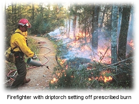
WHAT A DIFFERENCE A YEAR MAKESJUNE 02 -- SEA GULL LAKE, MN: A year ago the forest on Three Mile Island was an impenetrable tangle of downed trees and brush, a mess left behind after the massive windstorm of 1999.
Parts of the island -- after the fire -- now resemble a lunar landscape, bare rocks exposed where lush moss and brush once grew. Charred trees -- a few standing, most fallen -- are everywhere. What a difference a year and a big fire can make.
Woodpeckers, jays, warblers, and robins all returned to the island quickly after the fire, with plenty of insects around for them to eat. Seedlings are sprouting from the ash, including birch trees, raspberries, lilies, and more. Wild geraniums, their seeds dormant since the island's last major fire in 1801, are sprouting nearly everywhere. "The fire seems to have mimicked a wildfire very closely, which is what you want to see ecologically," said Allen Haney, a forest ecologist for the University of Wisconsin-Stevens Point who has been conducting research on the island for more than two decades. Haney was one of a dozen forest researchers and USFS personnel who recently visited the island; they were checking to see whether the fire met both the environmental objectives and the safety objectives as it consumed timber downed by the windstorm.
The fire was designed to burn slowly, starting downwind and backing upwind. But in areas where the wind damage was severe, the fire took off much faster than expected, shooting flames 60 feet in the air and burning fast even into the wind. The fire was so hot in spots that it melted aluminum flags left by researchers to mark their study areas. That's about 1,200 degrees Fahrenheit. Still, pockets of lush green growth remain across the island. In all, about 1,000 acres on the island burned, about 85 percent. The other 15 percent will act as seed source for regrowth of the forest.
Lee Frelich, University of Minnesota forest ecologist, says cedar trees at least 600 years old and perhaps more than 1,000 years old survived the fire. Frelich has documented these as the oldest in the state. He's identified one red pine stand that is 5,000 years old, and he expects most of them to survive for centuries to come. "Other species come and go, but they are unique," Frelich said. "They have survived fire and wind in a place where nothing else can. At least not for 600 years."
MODEL FOR FOREST RESTORATION CONTRACTS PLANNED IN BLUE MOUNTAINSJune 01 -- LA GRANDE, OR: Forest Service personnel and environmental activists are hoping that a new type of logging contract in the forests near La Grande will provide a model for restoration. La Grande District Ranger Kurt Wiedenmann is a proponent of innovative resource management contracts, including goods-for-services and stewardship contracts, new to the national forests and proposed for a restoration project near Spring Creek in the Blue Mountains.
The sale of timber at good market prices is essential for the contractors to make a profit; the La Grande Observer reported that the bid price for the Sprinkle Project will be offset by the restoration cost to the national forest. "Sprinkle is a more holistic approach to resource management," said Brett Brownscombe with the Hells Canyon Preservation Council. "It's worth looking at, and we hope the contractors will receive it favorably and get into more restoration service work instead of focusing exclusively on thinning and logging." The project was initially planned as a timber sale; then the Union County Forestry Committee became involved. "The intent of a stewardship is to involve communities and collaborate," said Brownscombe. "In the future, we want to see up-front community involvement and planning." Brownscombe and local forester John Herbst will help monitor the project, which will include logging of about 2,400 acres. The area contains a small patch of old-growth and a large number of small-diameter trees, both standing and downed; much of the area has been hit with beetle infestation. To protect the forest from fire, the smaller trees will be thinned. The monitoring committee has designated photography points to measure the progress of restoration. "The idea is to protect the old growth from fire," Brownscombe said. "The area is far more dense than it would have been. It's pretty clear in the Blue Mountains what we have left are relatively small-diameter trees, high-road density. The restoration needs are greater than just thinning, although thinning is a part of it, but so is road decommissioning, wildlife enhancement." The successful bidder on the project will remove smaller non-commercial trees and debris. Forest Service bookkeepers record the amount of restoration and deduct those costs from the bid price. Bids are expected to be awarded in early July. In areas where there are many dead and downed trees and heavy brush, the contractors must reduce the excess fuels to no more than 15 tons per acre. No trees larger than 21 inches in diameter will be taken; Hathaway estimates that between 15 and 25 tons per acre must be removed. "Leave the good trees, that's all we ask," Hathaway told the contractors. "We don't want mistletoe left."
CREWS GAINING ON TOK RIVER FIREMAY 31 -- FAIRBANKS, ALASKA: A wildfire near Tok slowed some yesterday and even weathered a thunderstorm that could have hampered firefighting efforts. The fire had burned almost 3,000 acres by yesterday evening, according to the Fairbanks News-Miner, but a two-hour thunderstorm in the early afternoon didn't generate the high winds that had driven the fire in its first two days. "They're in pretty good shape right now, as far as controlling these spot fires," said Pete Buist with the Alaska Division of Forestry. "But we're not calling them controlled." Reed's Type 2 team is assigned to the fire, which is burning in black spruce, tundra, and mixed hardwoods five miles southeast of Tok. The fire was spotted from the Tok Cutoff by a state Department of Transportation worker late Tuesday morning. On Wednesday, winds blew embers to the other side of the Tok River, which had separated the fire from Tok, a town of about 1,300 people. The largest spot fire was estimated at 50 acres and the smallest was about five acres. The fire was at first wind-driven, but it turned into a terrain-driven fire as it headed into the Tetlin Hills. "Fire moves more rapidly up slope," said Buist. "The fire still has the potential to grow and spread not only to the Tetlin Hills or the Alaska Range (to the south) but to the north towards town." A red-flag warning was issued because of the dry conditions and lightning from the thunderstorms.
VOLCANO FIRE IN HAWAII GROWS TO 4,200 ACRESMAY 31 -- VOLCANO, HAWAII: Firefighters are working to contain a rash of brushfires that have burned more than 4,000 acres on the western edge of Kilauea within Hawaii Volcanoes National Park. The Luhi fires, according to West Hawaii Today, were ignited by lava last Thursday and have picked up in recent days with dry, hot weather conditions. Two of three fires merged Wednesday and burned about 4,000 acres of unburned rainforest; the other fire burned another 235 acres. "Half of the East Rift Special Ecological Area burned, and the remainder is threatened," said Rhonda Loh, the park's vegetation specialist. Forty firefighters and four helicopters are working to contain the fire and prevent its further spread into the rain forest. A control line was established to protect three patches of lamu forests in the hairpin curves of Chain of Craters Road. The Hawaii Tribune-Herald reported that the fire was burning some of the same areas scorched by fires ignited by last year's Mother's Day lava flow. The fire, according to Jim Gale, the park's chief of interpretation, wasn't threatening any structures or visitors; the fires are burning in an open forest area dominated by uluhe fern. Last year, fires ignited by a lava on Mother's Day burned more than 3,600 acres.
|


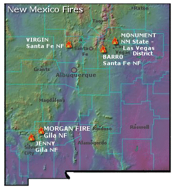 More than 250 firefighters, including seven hotshot crews, are expected to arrive today at the Virgin Fire. Two airtankers are assigned. The
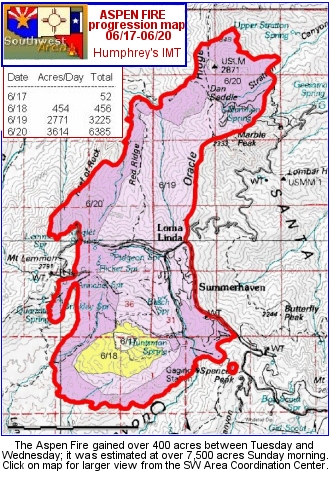
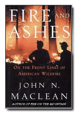 The collection of stories in FIRE AND ASHES proves up both Maclean's dogged pursuit of history and his determined focus on accuracy that comes from 30 years of journalism experience. Covering many thousands of miles, dozens of interviews, and painstaking attention to detail in his writing, Maclean has crafted a book that puts his readers out on the fireline.
 The
The 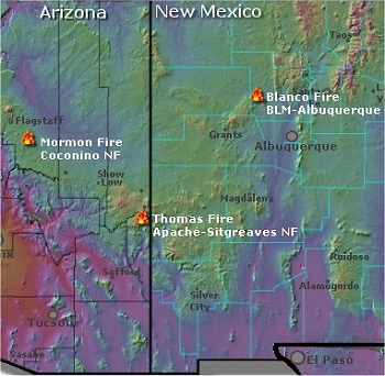
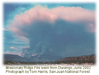 On the ninth day of the Missionary Ridge Fire, the fire created a small tornado at Vallecito Reservoir that ripped trees from the ground and killed birds in flight. Butch Knowlton, director of emergency preparedness for La Plata County, recalls that the valley became clear as the smoke was sucked into the funnel. He believes the vortex, which momentarily halted the fire's progress, may have saved homes at the north end of the reservoir. But at the same time, the vortex wrecked cars that had been moved into a "safe zone" in the dry lakebed at the north end of the reservoir.
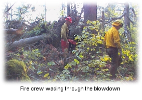 Heavy rain and straight-line winds in excess of 90 mph hit north-central and northeastern Minnesota on July 4, 1999, blowing down trees and causing severe flooding. On the Superior National Forest, 477,000 acres (more than 600 square miles) were impacted by blowdown, including one third of the Boundary Waters Canoe Area Wilderness (BWCAW). On the Chippewa National Forest, about 12,000 feet of lakeshore was severely damaged from erosion and 6,000 acres of timber was covered with blowdown.
 Last September, a Forest Service helicopter dropped ping-pong balls on the island. The goal was to get rid of the wind-broken trees drying wood wouldn't fuel a big wildfire ignited by lightning or careless campers. And, according to the
 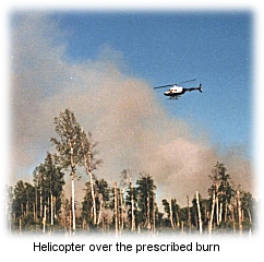 "It was a beautiful burn from our perspective," said Dennis Neitzke, Gunflint district ranger for the
 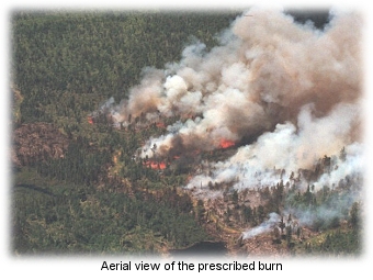 Roy Rich, a University of Minnesota grad student who is studying blowdown and fire effects on the forest, says it's an example of "accelerated succession." Across much of the blowdown area where there has been no fire, maple, birch, aspen, and fir are racing to take the place of downed pines. "After the fire, there were birch seeds everywhere," said Rich. "I think birch is going to be the big winner on this island after this fire."
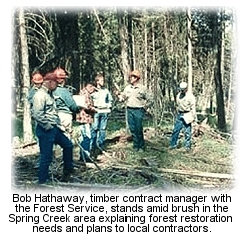 "These are multi-million-dollar contracts," Wiedenmann said. "Very serious business. We're creating jobs and meeting our resource objectives."